Friday 30 January 2015

A sense of direction

Unless you have become disorientated, I imagine that no matter where you are in the world, you would be able to indicate, say, the shortest distance to the sea.

Back in 2010 it was found that baby rats are born knowing which direction is which. That is to say, their head direction cells (HD cells) were fully mature and ready to use by the time they came to leave the nest. The question immediately arises then, which is that if humans are also born with a sense of direction, as rats are, why are some people so good at getting lost?

Researchers have identified two other cells in the brain—place cells and grid cells—and it is the way in which these interact which most likely explains why some people are better able to navigate a route between two points.

Place cells are thought to help us form a mental map. They were identified by Professor John O'Keefe, who made his breakthrough discovery in 1971, when he observed that certain nerve cells in rat brains were always activated when the rats were in one part of the room, others were activated when they moved to a different part of the room, and so on. This led him to the conclusion that these place cells, located in the hippocampus part of the brain, constitute a map of the space that is stored in the rats' memory.

Grid cells enable us to keep track of where we are, even in an unfamiliar place. They were identified by Professors Edvard and May-Britt Moser, and are located in the entorhinal cortex (the main interface between the hippocampus and neocortex). "The 'grid map' is like an empty map," May-Britt explains. "So it's like longtitudes and latitudes without the map. So you have a coordinate system. And then you have the communication with the hippocampus, where you have the memory. And the memory for the landmarks, for the environment, for everything, is put on top of this coordinate system."

"Without grid cells, it is likely that humans would frequently get lost or have to navigate based only on landmarks," Dr Joshua Jacobs has said. "Grid cells are thus critical for maintaining a sense of location in an environment."

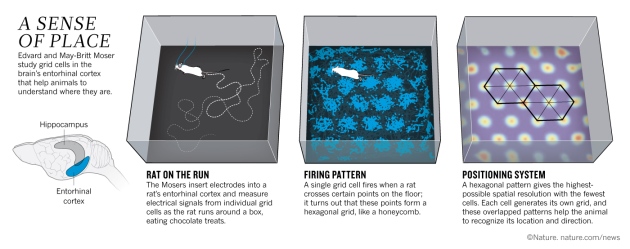
Image from Nature magazine

Dr Michael Kahana has added: "The present finding of grid cells in the human brain, together with the earlier discovery of human hippocampal 'place cells', which fire at single locations, provide compelling evidence for a common mapping and navigational system preserved across humans and lower animals."

This simple arrangement is complicated, however, by the fact that in laboratory conditions—which are about as far removed from normal day-to-day living as it is possible to get—gender differences become more noticeable. In some tests men do better than women, in other tests not.

"Thirty-five individuals were blindfolded and driven in a bus around a circuitous route for almost 20km in an Australian country town. At four points they were asked, whilst still blindfolded and in the bus, to indicate the direction of the point of origin of the journey. When the mean vector and the homeward component were calculated from the estimates, participants proved to be able to sense direction reasonably successfully. Females tended to have a better sense of direction than males" (source).

The Daily Mail writes that women "generally have a poor sense of direction" (source). The Royal Institute of Navigation (no less) goes even further: "It is a known stereotype that [...] women have no sense of direction" (source). Clearly this is not the case. What seems more likely is that women use the intellectual part of their brain more than men do when faced with certain navigational tests. For example:

"Male and female subjects were given the task of navigating through an unknown virtual 3D environment and the resulting brain activity was captured with fMRI scanning. Whilst there was a lot of overlap in the activated parts of the brain, a differential analysis showed a significant variation in brain activity between men and women. Women showed greater activity in the left and right pre-frontal regions, while men showed increased levels of activity in the hippocampus" (source) [pdf].

A study carried out by Professor Eleanor Maguire and Dr Hugo Spiers looked at how taxi drivers use the hippocampus and other brain areas as they navigate. This they did by getting the taxi drivers to drive a route in London using a virtual reality simulation, and recording the brain activity with an fMRI brain scanner.

The researchers found that the hippocampus is most active when the drivers first think about their route and plan ahead. When they encountered road blocks or other obstacles during the simulation, other areas of the brain were involved. The researchers also found that a part of the brain called the medial prefrontal cortex increased its activity the closer the taxi drivers came to their destination.

The hippocampus is the older (in evolutionary terms) part of our unconscious mind. It is also the part of the brain where place cells are found. It is thought that place cells help us to form a cognitive map, which serves an individual to help him or her acquire, store and recall information about the relative locations of his or her spatial environment. Thus:

"In tests of ability to navigate virtual 3D environments, there wasn’t a significant difference between men and women in success levels as long as the landmarks were left in place. When these were removed, men showed an ability to keep their bearings and had a significantly higher degree of success" (source).

When the landmarks were removed, the 'map' of the virtual world which the females had constructed in their heads was abruptly rendered incomplete. The males, who usually have difficulty finding a pair of socks in the airing cupboard, wouldn't have paid much attention to the landmarks in the first instance, and so were not unduly affected by their sudden disappearance.

“Everybody knows that men and women have some biological differences—different sizes of brains and different hormones," psychologist Tom Stafford has said. "We also know that we treat men and women differently from the moment they’re born. Brains respond to the demands we make of them, and men and women have different demands placed on them.”

Even so, it may be that men and women use different parts of their brain to navigate a route as a consequence of our hunter-gatherer heritage (source). Because women were more likely than men to forage for food, they were more liable to find themselves lost within a relatively short distance of the village. There was, therefore, every advantage to them in being able to memorise routes, particularly when—in situations like this—it is so easy to become disorientated. Likewise, because men were more likely than women to venture some considerable distance from the village on hunting trips, there was every benefit to them in being able to find a way home by "following their nose".

In summary, I am certainly not suggesting that men do not also use landmarks to keep them on track, and nor am I suggesting that women do not also rely on a sense of direction to help them navigate a route. I do however think that there are different emphases, and that these are more likely to manifest themselves in extreme situations, such as are found in laboratory conditions.

Navigation device from the Marshall Islands (Polynesia) showing
directions of winds, waves and islands.
Photo credit: National Geogrphic

Before closing, I would like briefly to discuss a related matter. According to Wikipedia, navigating a route between two points basically involves four stages:

i. Orientation (which, as discussed above, is a function of the mind, and is the ability to locate oneself with reference to place).
ii. Route Decision (which is the selection of a course of direction [my emphasis] to the destination).
iii. Route Monitoring * (which is the checking process to make sure that the selected route is heading towards to the destination).
iv. Destination Recognition (which is when the destination is recognised).

* It is during this stage that people are most likely to become disorientated. Route confirmation markers (like Hansel and Gretel's bread crumbs) are therefore essential, particular on Quietway routes (see also here).

The Universal Principles of Design written by William Lidwell, Kritina Holden and Jill Butler says: "To improve route decision-making, minimise the number of navigational choices, and provide signs or prompts at decision points. People prefer shorter routes to longer routes (even if the shorter route is more complex), so indicate the shortest route to a destination. Simple routes can be followed most efficiently with the use of clear narrative directions or signs. Maps provide more robust mental representations of the space, and are superior to other strategies when the space is very large, complex or poorly designed. This is especially true in times of stress, where the wayfinding may need to be adaptive (e.g. escaping a burning building)."

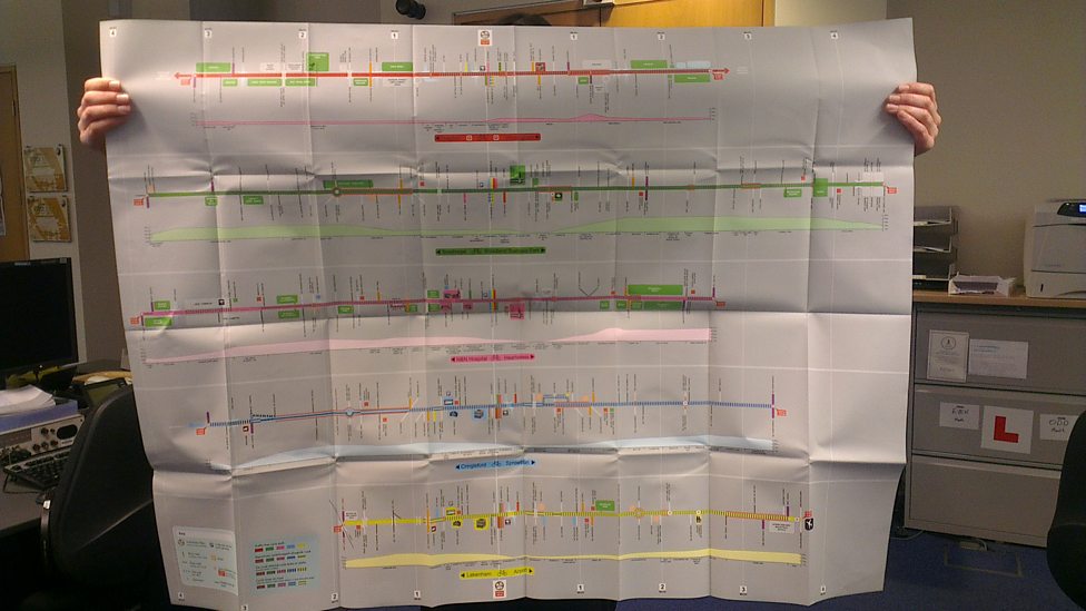
Norwich Cycle Map
Image from BBC Radio Norfolk

P.S. I was telling a friend about this blog, and when I got to the bit about the socks and the airing cupboard, she said that it reminded her of the time her son had come to her asking for a clean shirt. "It's on the end of your bed," she told him. He came back a minute later and said it wasn't there. So they went into his bedroom together, and she pointed it out to him. "Oh," he said, "the other end." 

Monday 12 January 2015

Some eye-catching reports

A couple of reports have caught my eye over the last week.

The first is a TfL-funded publication entitled International Cycling Infrastructure Best Practice Study [pdf]. As the title suggests, the main focus of this study is on infrastructure. Particular attention is paid to "design approaches in cities with high levels of cycling and / or recent significant growth in cycling numbers." The difficulties associated with applying these various design approaches here in the UK (governance, policy, funding, legal and regulatory frameworks) are also investigated.

One of the first things to be said is that "the best design solution in any location will arise from the context-appropriate application of sound principles and good standards; not from the cut-and-pasting of rigid design templates." The report also emphasises the importance of sustained investment: "What is needed is concerted action, on several fronts, according to a clear plan, over the long term."

Cycling: the way ahead makes related points in the chapter entitled, 'What needs to be known':

"Depending on the resources available, each town has to decide upon its priorities, and work out which specific actions are the most important. Reproducing apparently effective action taken elsewhere could have negative consequences if the concerted and coherent programme on which such actions were based is not taken into account. On the contrary, it is preferable to draw inspiration from known examples with due caution. Keeping in mind some of the constant factors of a thoroughly understood cycling policy, allow full recourse to the imagination and try to make the best use of locally-available resources."

The constant factors of a thoroughly understood cycling policy, by the way, are as follows:
i. network
ii. parking
iii. information
iv. education
v. training
vi. promotion
vii. sustained investment
[Edit dated 26/4/2020: "The most important part of a bicycle plan is the car plan." ― Dutch Cycling Embassy]

Different people reading the TfL-funded report are likely to pick up on different things, but here are a few things that stood out for me:

"There is clarity about the overall cycling network (including planned future development), with connectedness, continuity, directness and legibility all being key attributes."

"There is no differential cycle route branding, simply three principal types of cycle facility that make up well-planned and designed cycle networks."

"Cities with the largest cycling levels and the most cycling-friendly street-use cultures have achieved that status as a result of policy and associated action over the long term, with an incremental approach to improving provision. Continuity of commitment to cycling as a desirable and benign mode, one worthy of major investment, is essential."

"Some cities have shown that it is possible to grow cycling levels significantly over just a few years by employing pragmatic, relatively inexpensive, and sometimes intentionally ‘interim’ means of securing space for cycling. Upgrading this infrastructure to the standard found in mature cycling cities is not precluded (and sometimes consciously provided for) by the measures initially used."

The other thing that caught my attention was a blog by The Cycling Dutchman, Eric van der Horst, about the relevance of signage. He writes:

"'I just didn't know this was here!' I hear this line regularly from locals while doing cycle route surveying work. Completely surprised about the presence of a cycle route, he / she then also often states he / she 'lived here for twenty years'. It painfully shows how many British people hardly ever explore their own area on foot or bike beyond the merits of the main through-roads. Rushing off by car, they just don’t have a clue about other ways to get from A to B."

Missing links on Make A Gif
Useful links in Bristol not shown on the bicycling feature of Google maps
Images from Google StreetView

Eric continues: "The lack of proper signage is an issue which needs great attention. To get a country back on bikes, you need to show clearly in the field, in the public eye, where cycle routes are and where they will take you. Only this will truly encourage people to explore beyond what they know. Free cycle maps, on-line route planners and the occasional sign are all well intended, but generally only serve those who are already on the look out."

In another of Eric's blogs (Cycle lanes, cycle paths - what about a network?), he identifies two key principles of Dutch best practice. Firstly, 'think bike' at the beginning of a design and planning process, and secondly, think in terms of a network.

By thinking in terms of a network, plans are able to be put in place so that people can be connected to each other and to important public facilities such as schools, shops, railway stations, and so on. Extensive signage, Eric says, can make this network visible and is a relatively low-cost investment. Eric goes on to explain that the public must to be able to have confidence in these signs, which means to say, no missing gaps and reasonably direct routes (in Eric's words, "a trustworthy brand").

This lack of brand trustworthiness has been wryly exposed in an "infographic" by Mikael Colville-Andersen of Copenhagenize.com, entitled A Short History of Traffic Engineering (many thanks to Jitensha Oni for bringing it to my attention). It neatly satirises the cycle-route-starts-cycle-route-stops nature of our current "network strategy", a strategy so amazingly muddle-headed you have to wonder what problem traffic engineers think they are solving when adopting it.
Along with his local campaign group, Eric is currently working on a network design for Barnstaple. He says: "Of course, there are many routes which still need fixing. But if they are ready to go (even with some shortcomings), routes should get properly waymarked."

With a cycling network up and running, the value of Eric's first principle becomes clear. Every time a road is resurfaced, every time a junction is re-designed, every time a hole is dug in the ground, the question is asked: How can things be put back differently so that conditions are improved for cycling? (This is the true meaning of Going Dutch, incidentally.)

Saturday 3 January 2015

Vauxhall Gyratory Consultation Response

I do not normally respond to consultations, particularly in London, mostly because I feel that I would be talking to myself. However, this is an important scheme, and I felt that somebody needed to take a considered look at this, and say something.

Dear Sirs,

I am writing in response to the consultation on Vauxhall Gyratory.

I note that the main one-way system around Vauxhall is planned to be removed. However, the smaller one-way system in the north-eastern corner (Kennington Lane / Durham Street / Harleyford Road) is to be retained, I see, except that the one-ways are now planned to be reversed, so that they operate in the opposite direction.

The main vehicle flows will be as per this simple map:

A202 : orange / A3036 : dark blue / A3204 - A3205 : green
A203 : light blue

Between South Lambeth Road (A203) and, say, Vauxhall Bridge (A202), the northbound route will be different from the southbound route.

For a larger version of this map click here

Between Kennington Lane (A3204) and Nine Elms Lane (A3205), the main route would be via South Lambeth Road and Parry Street. That group of cyclists identified as the Strong and Fearless would probably find it quicker also to use this route. However, most utility cyclists would, I think, prefer to jump on the CS5 route underneath the viaduct, and then head south on Wandsworth Road (see red-coloured route below).


The works planned for the Vauxhall Gyratory do not preclude the possibility of a Quietway route through the Vauxhall Pleasure Gardens (green-coloured route), which I regard as a positive. However, given that the Mayor has said of these changes that they would be better than Amsterdam, the retention of the one-ways in the north-eastern corner, coupled with the fact that literally no cycle facilities at all are planned for the one-way section of Kennington Lane, means that this scheme falls somewhat short, in my opinion.


I would like to understand why installing some form of cycling provision on the northern edge of Kennington Lane (at least as far as the junction with Durham Street) has not been proposed.

You can see from the image above that the one-way system under discussion has been reversed, with the aim "to reduce queues on the approach to the viaduct". Thus there are now four traffic lanes on the Kennington Lane one-way, two to go straight on to Vauxhall Bridge, and two to go south to Battersea and Wandsworth.

In the year 2000, the average number of vehicles passing through Check Point 18463 (Kennington Lane one-way) each day was 29,357. This number has been falling steadily ever since, and in 2013 stood at 21,677 (26% fall).

We see a similar pattern through CP 8478 (Harleyford Road one-way): 33,437 motor vehicles in 2000, down to 22,883 in 2013 (31% fall).

Westbound-motor traffic on the A202 has just a single lane, all the way up Kennington Oval, all the way up Harleyford Road, and all the way up Durham Street. There it joins with westbound-motor traffic on the A3204, and well, have you seen that?

A3204 approaching the junction with Durham Street
Image from Google StreetView

So a single lane of westbound-motor traffic joins up with another single lane of westbound-motor traffic, and both feed into a one-way street. One plus one makes two, of course, which means that two lanes would be needed to accommodate all of the traffic through the one-way section, right?

Kennington Lane near the junction with Harleyford Road (the one-way
is to be reversed, and space set aside for four lanes of motor traffic).
Image from GoogleStreetView

TfL themselves say that Vauxhall’s potential to flourish is held back because it is dominated by traffic. They want to create a thriving centre for Vauxhall, they say, to make it a better, safer, more vibrant place for everyone who lives, works and travels through it.

This is interesting: "During peak hours, public transport users, cyclists and pedestrians account for 90% of all journeys, with motorised vehicles accounting for only 10%. However the current layout means that vehicles dominate, making it intimidating for pedestrians and cyclists."

TfL say that the proposals are still in the early stages, "with further development required particularly at Wandsworth Rd / Parry Street and Kennington Lane / Durham Street locations."

I set out to understand why some form of cycle provision had not been proposed on Kennington Lane. I still don't understand, and would be grateful for any light that you are able to shed on this issue.

Yours etc.

* * *

Tom Harrison from the London Cycling Campaign has said (source):

"I believe we need a dense grid of cyclable routes (roughly 400m x 400m). These need to be direct and enable everyone to cycle where they want to go. Much of this can be achieved on quiet roads, especially if you filter to make them quiet enough. But not all roads can be filtered, and therefore these need segregated tracks (to ensure risk averse cyclists are able to go on these streets). That is my vision, more or less. We also need to work with the way the political wind blows, which means supporting a scheme and trying to make it the best it can be to fit into the long-term plan."

I asked Tom which long-term plan he had in mind, but he wouldn't say. If he was thinking of the LCC-proposed grid, or the Sustrans-proposed grid, or the TfL-proposed grid, this would explain a lot.

It seems, at any rate, that the omission of a cyclable route on Kennington Lane was actually planned. How can this be?

Cycle Infrastructure Design (LTN 2/08) is very clear: "Networks should serve all the main destinations, and new facilities should offer an advantage in terms of directness and / or reduced delay compared with existing provision."

The National Planning and Policy Framework—which is in fact a material consideration in the determination of planning applications—is equally clear: the transport system "needs to be balanced in favour of sustainable transport modes, giving people a real choice about how they travel."

So when Tom says that we need a dense grid of cyclable routes which are direct and enable everyone to cycle where they want to go, there's absolutely no argument.

The second of the LCC's campaign demands says the following:

Make sure all planned developments on the main roads that they controls [sic] are complete [sic] to Go Dutch standards, especially junctions.

London is a city that is constantly being regenerated. If Dutch principles of design were made standard here, then in only a few years there would [be] excellent progress towards making many major roads and junctions safer for cycilng [sic] and walking. For example, London Bridge and Vauxhall Cross are both due for major changes in the next few years.

As things stand, there is a little bit of a cycle lane currently in place on Kennington Lane, and it is proposed that this be removed (#Smoothingtrafficflow).