Wednesday 2 September 2015

Quietways

This blog offers a critique of the Quietways programme. Q6, which passes through the site of the 2012 Olympics, will not form a part of this critique.


Cycle network planning is a process of improving community mobility by providing interconnected routes and facilities based on bicycle users’ needs.

Cycle route planning, therefore, aims to provide cycle routes that:

• convey cyclists safely, comfortably and conveniently for the greater part of their journey; and
• minimise conflicts with other users.

The Quietways have announced funding of £123m—contrast this with £54m for the Central London cycling grid—so with that sort of money available, it is reasonable to expect that the Quietway routes are going to be safe and comfortable. But will they be "direct" (Sustrans) and link "key destinations" (TfL)? Will they, in short, be convenient?

In order to be able to answer these questions, it is necessary to look at some maps.


The map above shows the first batch of Quietway routes (not including Q6), copied as faithfully as I can from this map provided by Sustrans. (Where TfL / Sustrans show two alignment options, I have plumped for the most direct route.)

In red are old LCN routes, and in purple are non-LCN routes. 64% of the Quietway routes shown above are made up of old LCN routes.

Are the Quietway routes direct? Q2 adds 2.2 km to the most direct route (19% further); Q4 adds 1.7 km to the most direct route (26% further); and Q5 adds 2.5 km to the most direct route (15% further). On the plus side, Q1 is just 40 metres further than the most direct route (between Edward Street and Cornwall Road), and Q3 just 50 metres further.

Some of the Quietways are often an assemblage of two or more old LCN routes. Q1, for example, which runs from Greenwich railway station to Waterloo, incorporates three different LCN routes. Actually this does not cause any problems here, but Q5 (from Croydon to Waterloo) is obviously made up of two very distinct routes—LCN 5 from Croydon to Clapham Common, and LCN 3 from Clapham Common to Waterloo—so this makes for less of a straight line and more of a dog leg. Using compass colours, Q7 (from Elephant and Castle to Crystal Palace Park) is made up of four different routes, and Q2 (from Walthamstow to Russell Square) of six different routes!

The point being that the course of a route is determined by the designer. In the case of the Quietways, it is fairly certain that subjective safety and deliverability have been extremely important considerations.

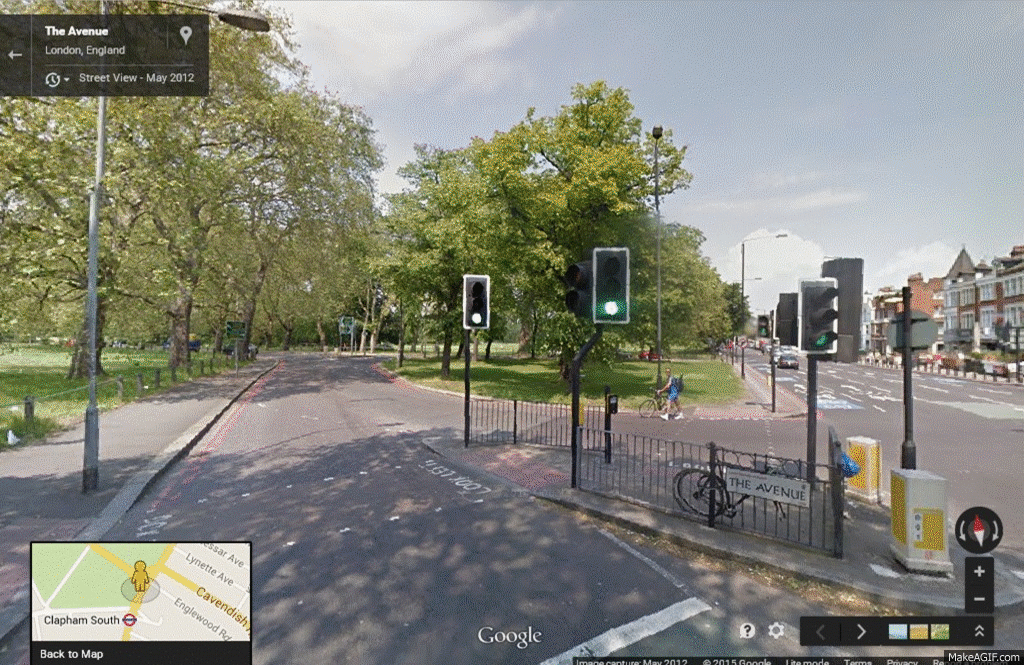
In all but about eight places the Quietway routes are already subjectively safe. Another feature is that, on the whole, these routes are pretty good, with restrictions to through-traffic (rat-running) already in place (e.g. the popular cycle route through De Beauvoir Town in Hackney, part of Q2).

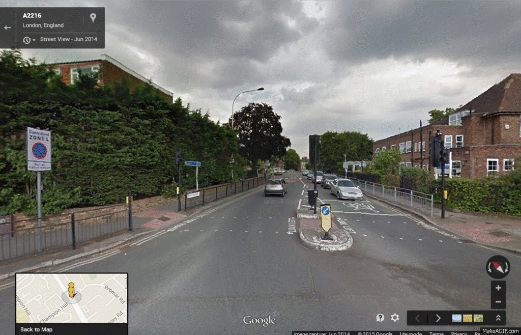
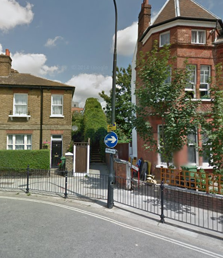
Chatsworth Road in Brent, part of Q3, and already closed to through-traffic.
Image from Google StreetView

From place to place, however, these routes need to be further improved (in order that they be made as direct as possible). Typically this involves converting one-way streets, or adapting shared use spaces. Not including Q4—more about which later—there are seventeen such interventions planned.

Non-functioning parts in blue, subjectively dangerous
parts in red

Transport for London has said:"Unlike the old London Cycle Network, Quietways will be direct and clearly signed, mostly on the road itself, making it difficult for cyclists to lose their way. Because they are on lower-traffic roads, they will be largely unsegregated. The main interventions on the vast majority of the network will be way-marking, surfacing improvements where necessary, removing barriers such as chicanes and improving the flow of the route. However, where directness demands the Quietway briefly join a main road, full segregation and direct crossing points will be provided, wherever possible, on that stretch."

There are a few places where these Quietway routes can be improved.


Assuming the idea is to get from Tooting Common to Clapham Common whilst completely avoiding Balham High Road / Balham Hill, the officially-proposed route (shown in black) is 200 metres further than the route shown in red (10% further), and 270 metres further than the route shown in green (13% further). I should also add that the officially-proposed route would not link in well with CS7.


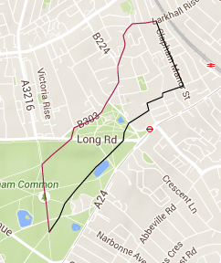
Assuming the idea is to get from Larkhall Rise to Clapham Common, the officially-proposed route is 50 metres further than the red-coloured route (3% further). Ordinarily I wouldn't regard this as a problem at all, except that if cyclists wish to head west towards Battersea Rise when they get to Long Road, the officially-proposed route would add 330 metres to their journey (31% further).


The officially-proposed route above left is 150 metres (20%) further than the alternative route, and above right 550 metres (192%) further.


The officially-proposed route above left adds 1.1 km to the most direct route (44% further), and above right 900 metres (24% further).


The Quietways also feature one very curious anomaly, as shown above. This area has previously been discussed on the Voleospeed blog. Colin writes: "The option that avoids the horrible roads the most is to go up Broadhurst Gardens and on to West End Lane (where the traffic is mostly static anyway). However, Broadhurst Gardens has not been made a contraflow" [source]. Camden Council have previously rejected the idea of two-way cycling on this section of Broadhurst Gardens [source], so the alternative seems to be to redesign the pedestrian foot-bridge (covered by vegetation in the Google StreetView image above). Clearly this requires some more thought.

* * *

The Quietway routes do not cohere, and this very much diminishes TfL's claim that the Quietways link "key destinations" (cyclists are not like trains on a track). This notwithstanding, a couple of quirks stand out.


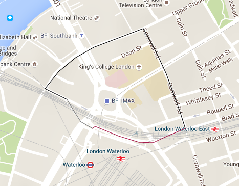
The TfL / Sustrans map says that Q1 goes from Waterloo to Greenwich. If cyclists actually want to go to Greenwich—as opposed to Greenwich railway station—the Quietway route would add 500 metres to their journey (35% further).

Image from Google StreetView

Q3 goes from Gladstone Park to Regent's Park. The place where Q3 ends, at the entrance to Regent's Park, does not allow cycling.

According to Tom Bogdanowicz, "LCC takes the view that Quietways must take people where they want to go, not stopping short of key destinations or running out at borough boundaries" [source]. I would like to see them express this view in much stronger terms, and not simply to leave it to the local groups.

* * *

Most of the Quietway routes either stop short of key destinations, or arrive at them in a roundabout way. Q4 does both.


My prediction for the route shown in black is that it would not help a single person make an everyday journey (except in part). It's a poorly conceived, poorly planned route.

* * *

According to another LCC report, the aim of the Quietways is "to overcome barriers to cycling, targeting less confident cyclists who want to use low-traffic routes, whilst also providing for existing cyclists who want to travel at a more gentle pace" [source].

This idea has been tried out a couple of times before, and hasn't worked yet. Beginning with the London Cycle Network, which sought to "cater for all age groups whether they are new to cycling or existing regular cyclists" [source], and on to the LCN+. "where people of all ages, abilities and cultures have the incentive, confidence and facilities to cycle whenever it suits them" [source], the effect is to set the bar too high, with the consequence that it is very difficult to get anything done ('soft' measures aside, and the occasional piece of 'hard' infrastructure notwithstanding).

TfL are now developing a cycling network a few routes at a time, and whilst this is arguably an improvement on what has gone before, there are still significant drawbacks to this approach. (If we do actually want a network, the current strategy of flurries of activity interspersed with long periods of stasis cannot reasonably be maintained: we are going to have to bite the bullet at some point.)

Cycling England published a report entitled Making a Cycling Town [here], which captured the experiences of the Cycling Demonstration Towns. It says:

"Finding the right target audiences is the essential starting point for cost effective behaviour change: ‘Which people can be motivated to cycle?’ and then: ‘Where do they want to go?’ and only thereafter: ‘What measures are required to help them take up cycling?’

"The starting point in each Cycling Demonstration Town was to identify which groups of people might be most likely to make such a shift, the maybe cyclists, and then to target them with a series of initiatives designed to overcome barriers to change.

"It was clear that the advice of local cycling groups needs to be considered in context (i.e. it represents the views of experienced cyclists and not necessarily of ‘maybe’ cyclists). The best results were had when local cycle campaigners worked hand-in-hand with the local authority, but where both acknowledged that the target audience was 'maybe' cyclists, and the needs of this latter group were actively and separately sought."

The 'maybe' cyclists are described in Cycling: the way ahead as "the mass of non-cyclists who are most likely to take up cycling again", and in Roger Geller's Four types of cyclist as "the Enthused and Confident". They make up about seven per cent of the population as a whole.

* * *

Tom Bogdanowicz's before-mentioned article begins thus: "If you haven’t heard much about the Quietways, you are not alone." Now, if members of the London Cycling Campaign haven't heard much about the Quietways, then what prospect is there that the target audience would be any better informed? (According to the Ranty Highwayman, the target audience "includes people who want to cycle but don't because of the danger, and people who don't know they would like to cycle yet!" [source].)

Tom goes on to explain that the "network designers" started with a list of 260 routes, each suggested by the London boroughs. This was reduced to a shortlist of a couple of dozen "priority routes", and then whittled down even further for what Tom calls "the first phase".

Tom notes that the Quietway routes are expected to comply with the six core design outcomes contained in the London Cycle Design Standards. These are: safety, directness, comfort, coherence, attractiveness and adaptability.

Tom explains that every route will be subject to a Cycling Level of Service assessment, which means that every section of route will be rated and awarded points from 0 to 6. Those sections of route with a zero rating will not, Tom says, get approval.

The factors which are likely to result in a zero rating are: left hook danger, cycle lanes below 1.5 m next to parked cars, 15% or more vehicles exceeding 30 mph, more than 1000 vehicles per hour at peak times and 5% or more HGV traffic.

* * *

The DfT publication Cycle Infrastructure Design (more commonly known by its serial number, LTN 2/08) points out: "Planning and designing high ­quality infrastructure involves developing individual, site­-specific solutions, but there are some common requirements that need to be satisfied. The underpinning principle is that measures for pedestrians and cyclists should offer positive provision that reduces delay or diversion and improves safety.

The Quietway programme targets not the Enthused and Confident cyclists, but the less confident cyclists (aka the Interested but Concerned). To be fair, this hasn't caused as many problems as it used to: where there is a conflict between routes which look safe and inviting and routes which are meaningful and direct, more often than not there has not been any compromise. This said, the "network" lacks connectivity and density, and in addition to which, there are more than a handful of instances where we have ended up with relatively lengthy diversions.

* * *

It is established beyond all reasonable doubt that good quality cycle infrastructure can't rapidly boost city-wide bike ridership without a network. Jose Marques Sillero from Seville expressed this idea in even more forthright language, saying that isolated cycle paths are "almost useless if they’re not connected, making a network from the beginning" [source]. David Hembrow is also very clear about this: "Good quality cycle routes are of almost no use if they are not very close together" [source].

The data supports these views. In 2013 two relatively high profile cycle schemes were completed in London, but in both cases there hasn't been any noticeable increase in the number of people using them:

CS2 Extension

2012: 1771
2013: 1688
2014: 1816

Royal College Street

2012: 1124
2013: 1071
2014: 1152

To remind you, the lesson from the Cycling Demonstration Towns appears to be that finding the right target audiences is the essential starting point for cost effective behaviour change.

Cycling England suggests that, at this stage, the right target audience is the 'maybe' cyclists, However, the LCC take a different view: "We are convinced it would be a mistake for the quality of any elements of the network to be designed in a way that makes them less suitable for any type of cyclists" (that is to say, the network must be suitable for experienced and inexperienced cyclists alike) [source].

I have tried to discuss this with the London Cycling Campaign, for example here. "What is the argument or evidence," I have asked them, "which says that providing for the needs of a load of people who don't yet cycle is more pressing than providing for the needs of a load of people who do (or who are most likely to)?" They didn't respond.

Conclusion

The Quietways will only work if they are meaningful, direct, effectively waymarked, and link in well with other routes (including those which function at a minimum level).

I have spent more than ten thousand hours drawing lines on a map of London in order to present the very same routes which make up the Quietways in a way that is coherent, simple to read and intuitively useful. However, I understand that my proposals for a comprehensive, city-wide cycling network are not likely to be taken forward for as long as the LCC are dominating the debate.

The LCC say: "It’s absolutely essential that these routes are actually ‘quiet’—the routes must be high-quality, direct, and cater for all cycling abilities, and they must provide safe and convenient passage through junctions" [source].

This is assertion. This is the world as it ought to be. At this stage in the development of an amenable cycling environment, except to say that a route must be direct, the LCC would not be able to supply any independent verification to support their view.

For myself, I truly believe that it is very much in the LCC's interest to drag things out for as long they can. This they have done over the last fifteen years, and are continuing to do it now, by making the task ahead as difficult as possible for everyone. Why should the Cycling Commissioner have to "fight" to get the Central London cycling grid up and running [source]? Simplify, simplify, simplify!


Tuesday 14 April 2015

Saint George and the Elephant

On the day that work began on the new North-South Cycle Superhighway, Andrew Gilligan was asked to explain the aim of the project. He said: "The idea is to separate cyclists and traffic going from Elephant and Castle to King's Cross. We're going to have a fully segregated, two-directional cycle track, which will also massively improve the whole look and feel of the whole area. Blackfriars Road is a kind of traffic desert at the moment; it's going to become an urban boulevard with trees, places for people to sit down, have a coffee, and it's just going to be so much nicer for everyone."

The only criticism I have read about the route alignment came from mikeybikey on the LCC website. He said: "'North-South' route doesn't even become such until section 2b [St George's Circus], with a big detour instead of going straight up London Road."

London Road is marked on the map above as the A201

Actually there is going to be a contraflow bus and cycle lane heading north up London Road, and a cycle lane heading south. It is the segregated route which incurs the "big detour".


I am curious to understand how this scheme is going to fit into the bigger picture. In order to do this, I am going to imagine that I am somewhere in south London, and that I wish to cross Blackfriars Bridge, not by car, but by bike. Whereabouts exactly am I?

The North-South Cycle Superhighway crosses CS7, so it is fair to assume that a lot of the cycle traffic which would use the new superhighway would have originated on CS7, as per the map on the left.


However, a more direct route (shown in blue) would reduce the journey distance by 190 metres, and cutting the corner (route shown in yellow) would further reduce the journey distance by an additional 60 metres.

Further back along CS7, an alternative route becomes available.


The map shows two routes from Clapham South up to Blackfriars Bridge. The journey distance for the blue-coloured route is 40 metres less than for the red-coloured route.

The blue-coloured route is very largely similar to LCN3; the red-coloured route shows the already functioning CS7. The blue-coloured route is worthy of further investment, because it links in well with other routes, and because mostly it is already safe and pleasant. If this route could be made fast and comfortable (no doubt for a fraction of the money that CS7 cost), there is every reason to suppose it would be well used.

The section of the north-south route on St. George's Road does not link in very well with CS7, but perhaps it is not really intended to do so. Perhaps the idea is that it should join up with the now-abandoned CS6, as shown in the map below left.


Except, actually, there is a more direct route available. The journey distance is 180 metres less using the blue-coloured route than using the red-coloured route.

As before, an alternative route is available for longer-distance journeys.

lcn 23

The map on the left shows two routes from East Dulwich up to Blackfriars Bridge. The journey distance for the blue-coloured route is 40 metres less than for the red-coloured route.

The blue-coloured route is very largely similar to LCN23; the red-coloured route shows the now-abandoned CS6. The blue-coloured route is worthy of further investment, because it links in well with other routes, and because mostly it is already safe and pleasant. If this route could be made fast and comfortable (no doubt for a fraction of the money that CS6 would have cost), there is every reason to suppose it would be well used.

* * *

A few years ago, TfL's Director of Integrated Programme Delivery, Ben Plowden, told a GLA committee hearing that the Cycle Superhighways have been a big success for commuters. But, he added, there are questions about how else to draw in people who are not in the demographic of 25-45 year-old males wishing to cycle into central London. Therefore, said he, it’s also worth thinking about the potential options for developing parallel routes, which would be quieter and probably more suitable for less confident, slower cyclists. And so he was going to look with the boroughs at identifying those routes which would complement the Cycle Superhighways, and deliver those.

Roelof Wittink, the Director of the Dutch Cycling Embassy, told the same committee hearing that in the Netherlands they ensure that there is a ‘disconnect’ between the main routes for cycling and the main routes for cars, so that there are fewer interactions between the two. Where those interactions are unavoidable, measures are taken to reduce the dangers.

We have already seen that for two routes, it is possible to create a disconnect between cycle traffic and motor traffic. Before we look at two other routes, a little bit of history.

Many of the present road bridges over the River Thames are on the sites of earlier fords, ferries and wooden structures. The earliest known major crossings of the river by the Romans were at London Bridge and Staines Bridge. The Anglo-Saxons built a bridge at Kingston (King's Town) some time before the Norman Conquest.

The most direct route between Kingston and Westminster is (certainly was) via Putney. Proposals to build a bridge at Putney were defeated by the Company of Watermen in around 1670.

According to one internet story, in 1720 Sir Robert Walpole (soon to be the UK's first Prime Minister) "was returning from seeing George I at Kingston-upon-Thames, and being in a hurry to get to the House of Commons, rode together with his servant to Putney, to take the ferry across to Fulham. The ferry boat was on the opposite side, however; and the waterman, who was drinking in The Swan, ignored the calls of Sir Robert and his servant, and they were therefore obliged to take another route."

Now, from the City of London you could get to Dover and Portsmouth easily enough. From the City of Westminster, however, you needed to cross the Thames by ferry. A timber bridge was built at Putney in 1729, which linked up with the Portsmouth road, but getting to Dover (and Rochester and Canterbury) still left travellers with an uncertain river crossing. The next bridge to be built, therefore, was Westminster Bridge (started in 1739 and finished in 1750). The Westminster - Dover road crosses the London - Portsmouth road at Elephant and Castle.


From Elephant and Castle you can go up to London Bridge via Newington Causeway. I see that TfL are planning to install a cycle lane on Newington Causeway, but I haven't included the whole length of this route in my proposed design for the simple fact that Borough High Street (the next road up) didn't feature in the LCN / LCN+ and is not part of the CSH programme.

The last route to be considered, then, is the one from Westminster Bridge to the Old Kent Road.

Orange: Quietway / Red: Cycleway / Black: No way

The whole point of telling you the story about the bridges and the watermen was to impress upon you the importance of this route. The orange-coloured (back street) route is 370 metres further than the main road route, so there would be every benefit in getting the main road route to work for cyclists.

I would like to suggest, if nothing else, the two red sections need to be joined up, and the A302 bit which is marked in black needs to function in both directions.

* * *

It is becoming increasingly obvious that cycling's high-profile schemes are being installed where there is spare capacity on the road network, higgledy-piggledy, and not necessarily where they would be of the most benefit to cyclists. If there is any controversy at all, or if it looks like there might be, the cycle route is either abandoned or diverted away from the direct line. This has happened how many times now?


And yet, strange to tell, the most effective way forward is known to us and easily within our grasp. Writing about CS1, Hackney Cyclist remarked: "In a way it is almost a shame that TfL didn't stick some blue paint down on the A10 a few years ago as we now might be getting money spent on upgrading cycling facilities on the A10, just as they are currently doing along the A11 in Tower Hamlets."

Plan the network, get it up and running, and then develop it further "on the basis of priority interventions and a timetable." What is it about this way forward which people don't like?

* * *

Getting the network up and running has all sorts of advantages. It would make cycling conditions safer, in part by making alternative cycle routes more numerous and easier to follow, and on main roads by providing regular physical cues—"clarity of design"—which thereby reduces confusion. Also, more highly engineered schemes are best developed within the framework provided by a functioning cycle network. As Cycling: the way ahead notes: "The existence of a plan increases the effectiveness of each intervention made in favour of cycling."

Cycling: the way ahead also says: "If it is not possible to systematically remodel the entire network to better meet the needs of cyclists [all in one go], specific action can be taken on each occasion that works need to be done. Most of the time, the additional expenditure needed to meet the requirements of cyclists is comparatively minimal."

In this country, of course, we do things quite a lot differently. Indeed, it very much looks as though all of the planned improvements along the North-South and East-West corridors (total cost £160m) are being paid for out of the cycling budget. The separate (but related) works at Elephant and Castle (total cost £25m) are likewise being paid for out of the cycling budget, "part of a £300 million plan to rebuild 33 of the most dangerous junctions in the capital" (source).


elephantandcastleroundabout.org points out that the planned works don't even extend as far as the existing adjacent cycle bypass, which means that until the next time perhaps, there is to be no investment in making these routes work better.

As Bruce Lynn of Southwark Cyclists said: "The outcome is not a big win for cyclists."

Tuesday 31 March 2015

Big Picture, Small Details

The Bristol Cycle Strategy says on page 9: "The desired cycle network in Bristol is large and intertwined and can appear quite confusing on a single page, particularly for those unfamiliar with Bristol."


It is worth taking a moment to consider why this map is in fact quite confusing. In the first instance it is because for some people reading a map is actually pretty difficult.

Professor Amy Lobben of the University of Oregon has noted that poor map readers tend to show more activation in the frontal lobe of the brain. (The frontal lobe is associated with attention, short-term memory tasks and planning.) This means to say, if people need to think about it too much, it's likely that they would struggle to read a map well.

People find it easier to turn a map—either in their heads or in their hands—so that it matches their direction of travel ('map rotation'). In addition, the most important map reading skill is the ability to relate where you are in the real world to the corresponding spot on a map (‘self-location’).

An on-street information panel, part of the Bristol Legible City programme.

Being able to shift one's perspective from the street-level view in front of you to the bird's eye view of a map, and being able to read a map whilst keeping north at the top of the page, are two attributes of good map readers. However, people vary in their ability to read maps. The Legible City programme overcomes this, firstly by ensuring that the map is correctly orientated, and secondly by locating the user ('You are here'). Of course, each on-street information panel has to be uniquely designed, but the idea is that if it will work for the first-time user, then it will work for everyone.

As I reported in an earlier blog, there are four stages to navigating a route:

i. Orientation (which is the ability to locate oneself with reference to place).
ii. Route Decision (which is the selection of a course of direction to the destination).
iii. Route Monitoring (which is the checking process to make sure that the selected route is heading towards to the destination).
iv. Destination Recognition (which is when the destination is recognised).


Most people settle upon their destination / decide upon their route at the beginning of a journey (stage 2), not during it (stage 3). Therefore, when you see people reading a map whilst they are out on their bikes, it is most likely that they are checking to see whether or not they are still on track. Route confirmation markers (like Hansel and Gretel's breadcrumbs) would obviously render this practice unnecessary.

The Universal Principles of Design written by William Lidwell, Kritina Holden and Jill Butler says: "To improve route decision-making, minimise the number of navigational choices, and provide signs or prompts at decision points." Another reason Bristol's cycle network map may be quite confusing to some people is that it shows too many routes. This problem is compounded by the fact that most of these routes are not waymarked in any way, which means that without the map no one would even know they existed.

Although these maps proved to be relatively quite popular (40,000 issued in the first year), the Bristol Cycle Strategy felt that the network needed to be communicated in a clearer way. Most likely this decision was a response to the Freedom to Ride manifesto advocated by the Bristol Cycling Campaign (BCyC).


It is an established fact that colour coding makes route planning easier, and for this reason, no doubt, BCyC developed the above-shown map. However, there are all sorts of problems with this design.

The main one is that there are not enough distinctive colours to code more than about fifteen routes. This has a number of consequences, such as, the map is relatively quite difficult for colour-blind people to read; maintenance of the scheme becomes increasingly time-consuming as the colours start to fade; a significant proportion of useful cycling routes are not coded, most notably in the centre.

Just recently, as part of Bristol's Cycle City Ambition Grant, Bristol City Council (BCC) published a map showing those routes which they have identified as the most worthy of further investment.


I converted the routes above into a more familiar format, and then set about trying to code as much of this network as possible.

The map above shows the routes identified by BCC.

For a strategic network aimed at utility cycling, it not necessary to code every single route which is useful to cyclists, only those which are the most useful. Please note the highest density of routes appear in that corridor which runs in both directions from the centre at about ten past eight on the clockface.

The map above shows the routes which make up my proposed network

There are obviously some bits of the BCC network which do not feature in the above-shown network, but nearly 80% of it does.

The map above shows the routes identified by BCC (Freeways / Quietways / Greenways) 
which do not feature as part of my proposed design


Finally, the concept of a Legible City is encapsulated in the statement: Big picture, small details (source).

Big picture: "The city is a large and diverse environment of people going about their business, interacting with one another in gatherings, events or simply passing each other on the street. Not one image, symbol or logo can truly represent such a diverse collection. The city is known by its name. What can usefully be unified are certain types of information – to help people get about and find places of interest, by pointing at things or letting people know how and when to use public transport, or by providing a consistent system of visitor information that is used by all."


Bristol Cycling Network (proposed)
View larger map here

Small details: "We all notice the little details. We recognise when a piece of information is incorrect, we get a feeling that a piece of furniture is flimsy or robust, and we react accordingly. When making improvements intended for mass usage, accuracy and attention to detail has to be of a standard to engender a level of trust that gives confidence. Good information in the right place at the right time is used by people. Poor information is ignored and vandalised. Usage is the litmus test of the success of any system."

City Centre map


Monday 9 March 2015

A dead moon of buoyant optimism

David Hembrow has recently reported how, a couple of years ago, Andrew Gilligan said that London's cycling environment was forty years behind that of the Netherlands. This gives the Dutch a start date of 1973.

David explained that what London needs to do now is exactly what the city has needed to do for the last 42 years, that is:

"Quietly get on with building a high quality grid of cycling routes 
to every destination and which absolutely everyone can use." 

David also managed a dig at the National Cycle Network. This seemed somewhat odd to me. Last year almost five million people used this network. Yes, there is a long way to go still, but finding the faults in a network which is being developed by a charity and which is 22,500 km long does not require much in the way of genius, and ought to be beneath someone of David's stature.

The NCN was launched twenty years ago. The SCN (London Cycling Campaign's plans for a strategic cycling network) was launched thirty-seven years ago. I wonder how that's going?

On the very same day that TfL published their plans for the North-South and East-West cycle superhighways, LCC described them "a success" and "a major step forward". Their "main concerns" were that some of the planned new junctions were "not safe enough" and that the width of the new cycle tracks was "too narrow in places". Overall, however, LCC were "really pleased" by the commitment to convert motor vehicle space into cycle space.

LCC regarded the conversion of one of the slip roads at Blackfriars Junction to a two-way cycle-only route as "a great feature". They thought it "the iconic location for the transformation of London into a city with real space for cycling". Clearly, however, they haven't stopped to think how this scheme would fit into the bigger picture.

David Hembrow writes: "This proposal was praised in some quarters as at least 
including some segregation of modes. What it actually demonstrates
is that the designers don't understand that bicycles are not the same as cars."

I am particularly curious to understand why cyclists would go down the slip-road and then double-back on themselves in order to head east (at least two cyclists are in the process of doing this in the publicity shot above). Where have they come from, and where are they going to?


The map above shows what is probably the best route for motor traffic between King's Cross and Parliament Square. The photo shows the approach (from the north) to the soon-to-be-converted slip road, with the bridge straight ahead..


The map above shows some of the main motor vehicle movements through Blackfriars Junction. Motorists wishing to travel to Parliament Square from the City, say, are enabled to avoid Blackfriars Junction altogether and get on to Victoria Embankment via White Lion Hill (pale red-coloured route).

Anyone wishing to travel to Parliament Square from pretty much anywhere south of the river could actually afford to give Blackfriars Junction a fairly wide berth. Indeed, very, very little traffic would cross Blackfriars Bridge south to north and then head west on Victoria Embankment. As the photo above right shows, most of the traffic goes straight on through this junction (from the south).

I am trying to understand why cyclists would come down the soon-to-be-converted slip road and then double back on themselves before heading east. Where would such a journey have started?
If the journey had started to the north of Blackfriars Junction, the more direct route would reduce the journey distance by 37% (map above). If the journey had started to the south of Blackfriars Junction (from Elephant and Castle, for example), the more direct route would reduce the journey distance by 39% (map to the right).
Whichever way I look at this, the answer always seems to be the same: there is almost no journey that cyclists would want to make which requires them to go down the slip road at Blackfriars Junction and then double back on themselves.


In the case of the route described above, the more direct route would reduce the journey distance by (only) 28%.

new csh
The new East-West route from Blackfriars Junction to Southwark Bridge (selected images)

Another thing to bring to your attention is that the section of route between Blackfriars Bridge and Southwark Bridge is not a destination in and of itself (there are no shops, for example). The point being that most of the people who travel along here want to be somewhere else. As the animation sequence shows, the only place that pedestrians are visible in any numbers is at Southwark Bridge.

Of course, there needs to be a way to connect the North-South route with the East-West route, and that slip road is probably the most suitable. But the new road layout would almost certainly better serve the needs of cyclists if it wasn't so massively over-engineered. (Since also one of the lanes on the slip road is pretty much entirely superfluous, why not plant a few trees there as well?)

I have no doubt that when these superhighways come to be built, a lot of kudos will go to Boris Johnson and TfL. But these schemes fall short in my opinion because they don't form part of a bigger whole.

The most effective way to develop an amenable cycling environment is to plan, study and then introduce a network—get it up and running—and thereafter to develop it further on the basis of priority interventions and a timetable. That's what the Dutch started doing in 1973, which means that this, therefore, is the true meaning of Going Dutch.

It seems obvious to me that the Cycle Superhighways are often going where they can be installed without causing too many problems, rather than where they would be most useful.


Why, for example, does the recently-announced CS1 replicate the old LCN10 almost exactly (except for the bits in red) when it was originally proposed to be routed along the main road? Improving the functionality of a couple of the crossings is well and good, but cycling needs density and connectivity, and despite its faults, the old LCN route at least had the advantage that it joined up to other routes (notably CS7). How is CS1 going to fit in with everything else?

Why, as well, does the new North-South route go from Elephant and Castle to King's Cross, rather than, say, from Elephant and Castle to Finsbury Park? It would mean that the North-South route on Farringdon Road would have to be extended by another 500 metres (shown on the map above right in red), but apart from that, there are no major problems with this route.

goo ner
Proposed route to Finsbury Park (selected images)
This route is functional in its entirety save for one regard: it is badly waymarked.

(The CS1 route is going to terminate at White Hart Lane (Tottenham), rather than continue up the A10 as the old LCN route used to do. If the new North-South route went to Finsbury Park, as I have suggested, rather than to King's Cross, as is planned, this would take cyclists past the Emirates Stadium (Arsenal). Perhaps someone at TfL is a dyed-in-the-wool Spurs fan, and this is why the route on Farringdon Road has been cut short by 500 metres? #COYS #UpYoursGooners)

Regarding the two new superhighways, baron samedi on the LCC website thinks the detail is sometimes mediocre and that compromises have been made to mitigate the effects on traffic. "Nevertheless," he continues, "these proposals take a lot of space from traffic, and provide a cycling environment that, at least on the main axis of the route, is suitable for all in most places. As a result, they'll open these routes up to many new cyclists."

Time will tell, but at least in the short-term, I think baron samedi is going to be proved wrong about this.