On page 57 of
Cycling: the way ahead, in the chapter which explains everything you need to know about
how to start developing an amenable cycling environment, is a table entitled 'Guide to general and specific measures for cycling'.
In the main body of the text, it is written: "All of the installation measures which call for little planning may be applied without major risk of error or loss. Most of the measures listed in boxes 1, 2 and 3 are inexpensive, simple to implement, easy to study and not strictly tied to the concept of a cycling network."
You can decide for yourself whether or not the measures suggested are indeed inexpensive, simple to implement, and so on, by following
this link. For the moment, however, I am more interested in box 4, which lists the works aimed specifically at cyclists.
The little picture of the bicycle going uphill indicates schemes which would require planning, and which would be difficult to implement or correct. As you can see, the column beneath is completely empty.
The picture of the bicycle travelling on level ground indicates schemes which would be independent of planning, and which would be easy to implement. It is interesting to note that the introduction of short cuts and the modification of hazardous crossroads (accidents) are both listed here.
The bicycle going downhill is saying that, according to the situation, planning is necessary or not, and implementation is difficult or easy. Clearly, then, these works would be as simple or as difficult as we want to make them. If we take the attitude that they are going to be easy to sort out, then they will be easy to sort out; and if we take the view that they are going to be hard to sort out, then they will be hard to sort out.
Well, I don't know about you, but I always find it inspiring to realise that we can improve our situation simply by changing our attitude. This said, as Warren Buffett has noted: "There seems to be some perverse human characteristic that likes to make easy things difficult." So we will have to see which way this ends up going.
You can see that the installation of a contraflow cycle lane on one-way streets, even on minor A roads, is one of those instances which is either difficult or easy to sort out. In the case of
Belgrave Road, local residents have responded favourably to the proposal put to them, so it seems likely that the new scheme would be allowed to proceed without too many problems.
Another one of those easy-to-do / difficult-to-do things is the "introduction of a network of cycle routes". This job would be made easy, I suggest, if we allowed that all of the network be introduced to the same level of functioning as, say, the Belgrave Road route. Conversely, this job would be made difficult if we insisted that all of the network be introduced to the same level of functioning as, say, the CS2 Extension.
The map above shows in blue all the bits of a proposed strategic cycle network which are currently non-functioning (not including Vauxhall Cross).
Building on the positives
I have previously spoken about the need to build on the positives of cycling, and not simply to focus on the removal of negatives.
The major cycling-related benefits are classified into the following categories:
- transport efficiency;
- cyclists’ health and fitness;
- economic and social impact;
- environmental protection.
"Transport efficiency" relates to the fact that, in the built-up area, the bicycle is generally quicker and more convenient than most other forms of transport. Thus it is written in LTN 2/08:
Pedestrians and cyclists need direct access to commercial, retail, education and employment areas. Non-motorised users are particularly affected by indirect routes because of the additional physical effort required and the sometimes considerable increase in journey time. Having an advantage over private car users in terms of distance and / or journey time will also help to encourage cycle use for short trips.
The network of routes for non-motorised users needs to be planned at a finer scale than the highway network.
How fine is a question of taste. In order to meet what it calls "the freedom of route choice requirement", CROW recommends a "mesh width" of 250 metres. (The mesh width is defined as the distance between parallel amenities.) For most practical purposes, however, Dutch cities strive to provide a mesh width of 500 metres for through-routes.
So anyway, I was looking at the proposed network map above, and it occurred to me that some of the gaps looked pretty big.
 |
| Full-size view available here |
Now, as it happens, I am able to fill some of these gaps using compass colours. The green-coloured routes have caught my eye, though as things stand, they have not yet been incorporated into my proposed design. Just to be clear, however, this is a strategic network I am proposing, so it is not necessarily the case that every single route which is useful to cyclists needs to be included as part of the primary network.
Let us recall that the purpose of "introducing" the network to a minimum level of functioning is threefold:
(i) to establish the network, ensuring that more highly-engineered solutions can be developed within the framework provided by a functioning cycle network;
(ii) to help to reduce potential conflict, firstly by raising the awareness of drivers, and secondly by enabling cyclists to ride in the correct position relative to other traffic; and finally,
(iii) to enable people to optimise their journey by making both route-planning and wayfinding easier.
Importantly—really importantly, I think—a network introduced to a minimum level of functioning would not make cycling conditions any worse than they already are. In fact, it would make them slightly better.
Reducing potential conflict
In September 2012, in my blog
Daring to redistribute space and means, I wrote: "It is acknowledged that many factors contribute to a bicycle-friendly environment. It is vital, for instance, that cyclists are visible to motorists at junctions."
 |
| Mile End Road near the junction with Bancroft Road |
More recently, in my blog
Blind-spot crashes, I wrote (interpreting SWOV):
In the short term, dangerous junctions could be adapted. This can be done by installing advanced stop lines. Where necessary, cyclists can be given a separate green light, or else research from Denmark suggests that the 'bike box' should be at least five metres deep (so that lorry drivers have a direct view of any cyclists who may be waiting ahead of them).
Now, looking at the photo above, this doesn't strike me as a particularly dangerous junction, and yet it was the scene of a cycling fatality recently. The need to get busy as quickly as possible cannot be stated strongly enough, therefore.
Mary Hassell, the coroner at the inquest of Brian Dorling and Philippine de Gerin-Ricard writes: "In my opinion action should be taken to prevent future deaths and I believe that [the Mayor] and Transport for London have the power to take such action."
Indeed. But given that these incidents can happen anywhere and everywhere, what action should be taken?
By way of an answer, let us take a moment to consider the Cycle Superhighways. There are two big problems with the Cycle Superhighways. The first is that in some circumstances, cyclists are placed in the incorrect position relative to the other motor traffic. This point has been made recently by Mary Hassell and Martin Porter,
The Cycling Lawyer. Martin pointed out that the current design, typified by a 1.5 metre-strip of blue paint, has no legal significance, and in some situations, "encourages cyclists to ride in an unsafe position too far over to the left."
The other big problem is that the routes do not join up to anything. This is from
Cycling: the way ahead for towns and cities: "The existence of a network plan increases the effectiveness of each intervention made in favour of cycling."
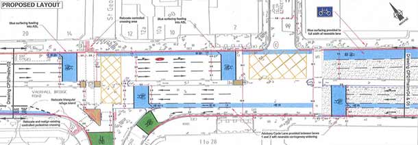
Vauxhall Bridge Road (left) and Belgrave Road (right)
Anyway, TfL have recently decided to re-route the course of CS5 (details
here). I'll come back to this later on, but for the moment, I just want consider what TfL have got planned for the new route.
Because Belgrave Road is fairly quiet, we wouldn’t need to make any changes to the road, apart from intermittent markings—square symbols every so often on the road surface to reassure cyclists that they were on the right route. There wouldn’t be any continuous lines of blue paint. There wouldn’t be any physical change to the vast majority of the road. There wouldn’t be any changes to the bus stops. And there wouldn’t be any loss of parking.
The only thing we would need to do would be to install a contraflow southbound cycle lane at the very top end of Belgrave Road [...] and also to do something similar across Eccleston Bridge and into Belgravia.
The only thing? We have already seen how important it is for cyclists to be visible at junctions. This notwithstanding, I think that—I think that Britain is essentially a vehicular cycling country. Like many cycle advocates, I would like to see this change much more towards the Dutch model. However, there is not yet one town or city here that has got even the basics in place. Given where we are now, and how far we need to go, I am attracted to this idea of repeat markers laid on the road surface. I'll come back to this later on.
 |
An extract from Cycling: the way ahead for towns and cities, the only
publication out of Europe to answer the question, How to start? |
All sorts of reasons have been put forward to explain the route change to CS5, but to my mind, the most persuasive has been suggested by
Ken Sparkes of Warwick Square: "Looks like TfL planners pushed CS5 up Vauxhall Bridge Road and then freaked out at Victoria Station."
Ken continues: "Nobody has really figured out how to get cyclists safely from Vauxhall Bridge, past Victoria Station and on to Hyde Park and Marble Arch to join the superhighways coming down from the north."
Even so, according to the criteria listed
here, the course of the originally-proposed route is the most desirable. Prudence demands that this route would be "introduced" to a minimum level of functioning, and then developed further on the basis of priority interventions and a timetable. In this country, however, there is a good deal of resistance to this idea.
I can’t guarantee it as a responsible civil servant. I can't pass it on to the public because I can't guarantee the standard of the quality of the route. If people do their own thing, that’s fine; but if a route is introduced to a minimum level of functioning, people can quite rightly say: "Well actually, I tried to go along your route, and it was a nightmare, and I had an accident." And like: "I’ve lost my daughter now. What do you say about that?" You’re completely liable and responsible for it, so I can’t.
The Manual for Streets acknowledges the reluctance of some authorities to implement schemes that do not meet all of the safety criteria, for fear of litigation. Obviously this has had—is still having—a paralysing effect.
Nobody made a greater mistake than he who did nothing because he could do only a little. - Edmund Burke
To avoid situations in which you might make mistakes may be the biggest mistake of all. - Peter McWilliams
It isn't making mistakes that's critical; it's correcting them, and getting on with the principal task. - Donald Rumsfeld
The only real mistake is the one from which we learn nothing. - John Powell
If you have made mistakes, there is always another chance for you. You may have a fresh start any moment you choose, for this thing we call 'failure' is not the falling down, but the staying down. - Mary Pickford
If you're not making mistakes, then you're not doing anything. I'm positive that a doer makes mistakes. - John Wooden
The man who never makes a mistake is the man who never does anything. - Theodore Roosevelt
I get the sense that for many cycle advocates, things have also become very black-and-white: either do it properly, or don't bother. The upshot is that people are now finding themselves having to deal with a false dichotomy, when in fact there is at least one additional option to be considered.
Dans ses écrits, un sage Italien / Dit que le mieux est l'ennemi du bien. - Voltaire
In philosophy, the desirable middle between two extremes—the one of excess and the other of deficiency—is referred to as 'the Golden Mean'. Socrates, for instance, teaches that a man "must know how to choose the mean and avoid the extremes on either side, as far as possible". See also
The Doctrine of the Mean (Confucianism) and
The Middle Way (Buddhism).
To begin with, Lynn Sloman suggests, the focus of our attention should switch from a few grandiose schemes to thousands of small initiatives. "Even if their impact is not massive,"
Cycling: the way ahead explains, "it will be real."
CS5 route change
It has obviously proved necessary to compromise on the delivery of certain aspects of this route.

Andrew Gilligan writes that about 1600 cyclists a day use Vauxhall Bridge Road. He also predicts: "that a substantial proportion, but not all, of the cyclists currently using Vauxhall Bridge Road will switch to the new route." But why would they?
The main reason that most regular cyclists would use Belgrave Road from Vauxhall Bridge would be to get to Hyde Park Corner (as per the dashed red line in the map above). This they can currently do. In future, they would be enabled to make the return journey, but having said this, what cyclists would have to do in order to be able to access Belgrave Road southbound (from Hyde Park Corner) seems more than a little hairy.
Looking at this strategically, another key destination from Vauxhall Bridge would be St James's Piccadilly. It is at this point that I need to hold my hands up and say, I didn't see this green-coloured route until just now. But in terms of journey distance, it is a good one: 0.46 mile shorter than the red-coloured route, and 0.12 mile shorter than the combination of routes I had planned.
Warwick Square residents were told that CS5 "needs some way to get from Vauxhall Bridge up to Hyde Park. The original Vauxhall Bridge Road plan is a bit complicated, so TfL want to shift it onto Belgrave Road via Bessborough Street."
Okay, but it looks like the route is going to end somewhere in Victoria, probably at the junction with Ebury Street. So as things stand, cyclists wishing to carry on to Hyde Park and Marble Arch may end up having to "do their own thing". This is because the alternative route—LCN 5 via Lowndes Square and Albert Gate—would add over half-a-mile to the most direct route, and over a third of a mile to the second-most direct route, and it is unlikely that [m]any cyclists would be prepared to go this far out of their way.
Andrew Gilligan writes that "above all", the new cycle route "allows cyclists to reach a much wider area north of Victoria—and much of Victoria itself, via Buckingham Palace Road or the Ebury Street cycle track—without passing through the gyratory system at all."
This is very misleading. The "much wider area north of Victoria" is in fact already accessible via Ecclestone Bridge northbound, and Elizabeth Bridge southbound, and is almost entirely residential (Belgravia). Furthermore, the link to Buckingham Palace Road and Ebury Street is not worth nearly as much as Andrew Gilligan implies, and not just because of all the one-ways.
Andrew Gilligan has written that CS5 "was planned to come from New Cross and Peckham, over Vauxhall Bridge and up Vauxhall Bridge Road, ending at Victoria." He continued: "Nobody liked that idea much, frankly."
But what didn't they like about it? The fact that the route ended at Victoria, not really joining up to anything? Or that the proposed programme of works were, in the words of Warwick Square residents, "a bit complicated"?
Is it safe?
The rationale behind the route change seems fairly clear-cut, namely, that for all but the small group of people who have the equivalent of Bikeability Level 3.5 training, the junction around Victoria is too dangerous. And so, there was this idea to reconfigure the layout of the road hereabouts in order to make conditions for cycling safer.
 |
Annual Average Daily Flow (AADF) figures for Mile End Road / Bow Road -
the 2005 spike in cycling came about as a result of the 7/7 bombings. |
There has been a marked rise in the number of serious and fatal injuries on Mile End Road / Bow Road over the past few years, and the connection between this and the development of CS2 cannot simply be brushed aside. Indeed, if the evidence of "the CS2 experiment" serves as any guide, there would appear to be a very real prospect that any road "improvements" to Vauxhall Bridge Road along the lines originally planned would have the opposite effect to that which was intended.
Therefore, by replicating the road conditions of CS2 on Vauxhall Bridge Road—no, let's be honest: the road conditions would probably have ended up being worse than CS2—for instance, the original design required cyclists to ride between two lanes of moving traffic for a distance of five hundred feet or more—this was likely to be a PR disaster in the making.
Thus CS5 was given a route change and—Hey presto! problem solved.
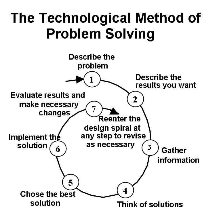 |
Technological Method of Problem Solving.
Copyright © 1993 Adapted from Hacker & Barden, Living with Technology.
|
Except of course that the problem has not really been solved, it's just been side-stepped.
Describe the problem
The CS2 route change has thrown up a significant issue which really does need to be dealt with head-on, and that is, to identify the best short-term solution for treating roads like Vauxhall Bridge Road.
Martin Porter writes: "Personally I do not buy the argument that putting down paint is a useful indication to motor traffic that cyclists may be present. Any driver, especially in London but also elsewhere, is criminally negligent if he does not consider the likely presence of cyclists on any highway. Are we implying that where there is no blue paint drivers are not obliged to consider the likely presence of cyclists?"
I have left
a comment on Martin's blog, because he raises some important issues, and I think it would be a great help if he would clarify his thoughts in this area. But however much you are persuaded by the basic thrust of his argument, it does rather seem that there is a disconnection between his premise and his conclusion. I am not saying Martin is wrong, necessarily, just that his main point does not logically follow on from his first point.
Photo credit: The Cycling Dutchman (left) and As easy as riding (right)
On busy roads, high-engineered solutions are, I believe, the most appropriate way to provide for cyclists of all abilities. The reality is, however, that these solutions cannot simply and quickly be installed (except, perhaps, here and there). Therefore, it is good practice to "compare possible solutions against constraints and criteria".
I am not going to consider all the various options here, not least because this is already proving to be quite a long blog. My preference in the short-term is for repeat markers laid on the road surface. As necessary the map can be marked to show dangerous connections, and then let people decide for themselves which route would suit them best.
What I mean by a 'dangerous connection' is that a section of the network is regarded as so brimful of potential conflict, let's say—so perilous—that it could only be used safely by someone who has Bikeability Level 3.5 training. Such a 'difficult' section as this could be shown on the map with a dashed line.
People trained to Bikeability Level 3 should, I suggest, be able to use all the rest of the network without let or hindrance.
Mark Ames has recently written: "If infrastructure
is going to be built that more vulnerable cyclists are to be expected to ride on then it must be done properly." Yep. But city-wide, this infrastructure might take eight years to develop, or eighteen years, or even eighty years, and there has to be some thought given as to what should be done in the meantime.
The thing about repeat markers laid on the road surface, as before said, is that for one thing, they wouldn't make cycling conditions any worse, and that for another thing, they would help to reduce potential conflict, firstly by raising the awareness of drivers, and secondly by enabling cyclists to ride in the correct position relative to other traffic.
Martin's point, that motorists should behave courteously to cyclists at all times, on or off the cycle network, is well made. All I can say by way of a reply is that my proposed cycle network does more than the bus network does. Yes, okay, it doesn't do everything. Fair enough. But I think that is just one of those things. Besides, any gaps in the strategic network could be filled with—local 'solutions'.
Think of solutions
Another way of dealing with a road like Vauxhall Bridge Road—as a cyclist, I mean—is simply to avoid it. This is what I was talking about when I said, give people the information and then let them decide which route they want to take. The worse thing about the new CS5 route, then, is not that it avoids the junction near Victoria station, but that it comes to an end without joining up to anything meaningful.
Cycling: the way ahead makes the point that only by studying a cycle route network does it become possible "to truly grasp the situation, to draw up a list of black spots and to act in a targeted and highly efficient fashion."
In terms of a 'network first' approach, it is helpful to embrace what might be called 'whole systems thinking'. An important feature of this process, particularly in the very early years, is to make the minimum change for the maximum effect. (If you don't like this, or don't agree, please say why.)
 |
| A cyclist "doing his own thing" at Hyde Park Corner. |
The point I am working towards is that there is simply no getting away from the fact that Hyde Park Corner needs to be reconfigured in some way. Even so, the dictum 'minimum change maximum effect' could still hold true. It's just that in this instance the minimum change would actually amount to a highly-engineered solution.
I have spent quite a lot of time at Hyde Park Corner, and I have seen that there are three sets of traffic lights at various points around the junction. My thought was to try to make the best use of these. The 'minimum change', therefore, would be to keep the number of traffic lights the same as they already are.
Of course, it is going to prove necessary to reallocate some of the carriageway space in favour of the cyclist. The question is: Can this be done in such a way as not to unduly affect the smooth flow of traffic?
 |
| Duke of Wellington Place looking north |
 |
| Duke of Wellington Place looking west |
Approximately one lane on the driver's off-side (i.e., adjacent to the traffic island) would need to be reallocated to the bicycle.
 |
| Grosvenor Place near the junction with Chapel Street |
There is simply no need to accommodate this right-turn here. Motor traffic can in fact more easily access Belgrave Square via Grosvenor Crescent, so you have to wonder what all these car- and van-drivers are actually thinking.
My proposal here would be to remove the bus lane, to have two lanes of motor traffic southbound, no right-turns allowed, and two lanes of motor traffic northbound, three at the junction with Duke of Wellington Place (see the photo with the Kuehne + Nagel truck above).
The cycleway can run either down the middle of the road or on the western side of the road.
(Note dated 21/11/2013: The thing about running the cycleway down the western side of the road is that, unless you pause the traffic in between light changes, cyclists would have a guaranteed red at this junction. The other thing to consider is how cyclists would be expected to proceed if they wanted to carry on southbound down Grosvenor Place towards Victoria station. The thing about running the cycleway down the middle of the road, as far as Chapel Street, say, is that it would be necessary to install a contraflow cycle facility on the southern side of Belgrave Square.)
Conclusion
The six constant factors of a thoroughly-understood cycling policy are:
i. network
ii. parking
iii. information
iv. education
v. training
vi. promotion
There is not one town or city authority in this country that could contemplate that list with a sense of quiet satisfaction. So there we go.
And which of these factors is difficult to provide? If we take the view that the "introduction" of a cycle network is actually quite simple, then surely there is nothing on this list which an authority committed to making a long-term investment in active travel would regard as challenging.
Can it be true, therefore, that it is a fear of making mistakes that is holding us back?