Networks
Signed cycle route networks can help to encourage walking and cycling. Pedestrians and cyclists need direct access to commercial, retail, education and employment areas. Non-motorised users are particularly affected by indirect routes because of the additional physical effort required and the sometimes considerable increase in journey time. Having an advantage over private car users in terms of distance and / or journey time will also help to encourage people to walk or cycle (in preference to using the car) for short trips.
The network of routes for non-motorised users needs to be planned at a finer scale than the highway network, so that walk and cycle distances are minimised. However, it is important to avoid creating long, narrow routes that are not overlooked by adjacent properties, as these can give rise to anti-social behaviour.
Signed cycle routes can offer “fine grain” networks, with greater accessibility than for motor traffic, by using quiet residential roads, contraflow schemes, paths alongside rivers and canals, disused railways, vehicle restricted areas and parks. Opening up paths for cycle use, such as when implementing a Rights of Way Improvement Plan, may benefit pedestrians too. The upgraded surface of the Thames River Path (photos below) provides a good example.

| 
|
Route improved by removing a gate and providing a wider, sealed surface
Cycle routes on back streets and off-road routes need to be clearly signed, and changes in direction should be kept to a minimum. However, a balanced approach to signing is required to avoid clutter. Designers should investigate options for modifying existing signs, or mounting new signs on existing poles or other street furniture. Creating a smooth physical interface between different elements of a route by using, say, dropped kerbs also helps to create a continuous, legible and coherent network that is easy to follow.
Consultation with local cyclists both before and after scheme implementation will tap into local knowledge to help to identify and prioritise the development of a cycle route network.
Detailed route design entails development of a series of site-specific solutions. It can be difficult to apply a standard solution to the kind of issues that arise when designing for pedestrians and cyclists. Cyclists and pedestrians may, for example, ignore formal crossing points. One way to consider the process of infrastructure design is through a behavioural approach. Essentially this involves observing how users interact, and then formulating a solution that accommodates the main movements of each mode, while minimising the potential for conflict. This may be preferable, less unsightly and more practicable than installing an arrangement that attempts to divert people from their desire lines through the use of guard railing, signs and road markings. Such an approach may require a move away from the idea of fully segregated areas for pedestrians, cyclists and motorists.
Risk and liability
The Manual for Streets acknowledges the reluctance of some authorities to implement innovative schemes or schemes that do not meet all safety criteria, for fear of litigation. However, the vast majority of claims against highway authorities relate to maintenance defects rather than deficiency in design. An authority should not be exposed to claims if there are robust design procedures in place where the resulting decisions are recorded in an audit trail. The Manual for Streets suggests the following approach:
•set clear and concise scheme objectives;A risk assessment may be undertaken as part of the design review process to determine the scale and likelihood of any perceived hazard, and it can be beneficial to involve user groups in this process. It is essential that the risk assessor fully understands the relative risks of various options. A common decision on cycle route provision involves choosing whether to take cyclists off the carriageway by providing a cycle track. Making such a decision is rarely as straightforward as it might seem at first. A cycle track frequently interrupted by side roads can have a significantly worse potential for accidents than the equivalent on-carriageway facility.
•work up the design against these objectives; and
•review the design against these objectives through a quality audit.
The assessor should determine if the proposal improves upon the existing situation and whether any risk is justified when compared with alternative solutions.
In the shell of a nut
Networks
"A cohesive and direct bicycle network ensures that a bicyclist will be able to take the easiest and shortest route between destinations. This makes biking quicker, more convenient, and more enjoyable."
Burns and Blasko, 2012
Risks
“In my view, regulation and safety standards in this country are not designed on the basis of evidence as to road user conduct, and what is needed to reduce risk given observable behaviour and events; rather, they are designed as abstract engineering exercises with the principal purpose of making it harder for road accident victims to bring successful litigation against highway authorities (and engineers).”
Daniel Moylan, 2003
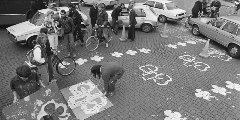
 |
| Photo credit: Pete Owens |
Assessment
Networks
I could point you to dozens of cycle networks in the UK that fall short of the criteria indicated above, but not one that meets them all.
In Darlington, for example, which has the unique distinction of having been both a Sustainable Travel Demonstration Town and a Cycling Demonstration Town, the emphasis was on developing the quietest—not the most direct—routes to destinations. Indeed, as the local cycle campaign group noted in 2007: "A potpourri of recorded cycling situations in Darlington shows a town that is trying to build a series of cycle routes, some comfortable at times, some provisional, most never quite getting from A to B in any meaningful sense."
Perhaps I will take a closer look at Darlington some time. The Guardian suggested in an article from 2006 that Darlington is "the crucible of a grand experiment". There's a lot riding on it, they pointed out, before quoting Philip Darnton from Cycling England: "If we're wrong," he said, "we've blown it completely."
The local authority had set relatively modest targets for its work, hoping to increase the number of people cycling by 200% (that is, to raise the modal share of cycling from 1% to 3%). Sadly, according to the BBC, the increase was just 27% (that is to say, a shortfall of 173%).
Now, I have spoken recently to the Local Motion team in Darlington, and it is not all bad news. About seven or eight per cent of school children ride their bikes to school, for example. But even so, if the UK is to develop a successful cycling culture, it is obviously important that we profit from these "mistakes" by trying again in a different way.
Risks
During a recent telephone conversation with a Cycling Officer somewhere, I made the point to him that engineers like to see things written down. The idea of "introducing" a cycle network so that it functions—albeit at a minimum level to begin with—has been written down. Indeed, it is regarded as "a prudent course to follow" by the only publication out of Europe to answer the question, How to begin? Conversely, a refutation of this idea is not written down anywhere (except by the London Cycling Campaign and their followers).
The following is taken from Manual for Streets:
A major concern expressed by some highway authorities when considering more innovative designs, or designs that are at variance with established practice, is whether they would incur a liability in the event of damage or injury.
This can lead to an over-cautious approach, where designers strictly comply with guidance regardless of its suitability, and to the detriment of innovation. This is not conducive to creating distinctive places that help to support thriving communities. In fact, imaginative and context-specific design that does not rely on conventional standards can achieve high levels of safety.
Most claims against highway authorities relate to alleged deficiencies in maintenance. The duty of the highway authority to maintain the highway is set out in section 41 of the Highways Act 1980, and case law has clarified the law in this area.
The most recent judgement of note was Gorringe v. Calderdale MBC (2004), where a case was brought against a highway authority for failing to maintain a ‘SLOW’ marking on the approach to a sharp crest. The judgement confirmed a number of important points:
• the authority’s duty to ‘maintain’ covers the fabric of a highway, but not signs and markings;Some claims for negligence and/or failure to carry out a statutory duty have been made under section 39 of the Road Traffic Act 1988, which places a general duty on highway authorities to promote road safety. In connection with new roads, section 39 (3)(c) states that highway authorities ‘in constructing new roads, must take such measures as appear to the authority to be appropriate to reduce the possibilities of such accidents when the roads come into use’.
• there is no requirement for the highway authority to ‘give warning of obvious dangers’; and
• drivers are ‘first and foremost responsible for their own safety’.
The Gorringe v. Calderdale judgment made it clear that section 39 of the Road Traffic Act 1988 cannot be enforced by an individual, however, and does not form the basis for a liability claim.
Most claims against an authority are for maintenance defects, claims for design faults being relatively rare.
Advice to highway authorities on managing their risks associated with new designs is given in Chapter 5 of Highway Risk and Liability Claims. In summary, this advises that authorities should put procedures in place that allow rational decisions to be made with the minimum of bureaucracy, and that create an audit trail that could subsequently be used as evidence in court.
Suggested procedures (which accord with those set out in Chapter 3 of MfS) include the following key steps:
• set clear and concise scheme objectives;
• work up the design against these objectives; and
• review the design against these objectives through a quality audit.
A Case Study
Let us consider how the foregoing is being applied in that city which, as has been said, is "very much addicted to the flowery part".
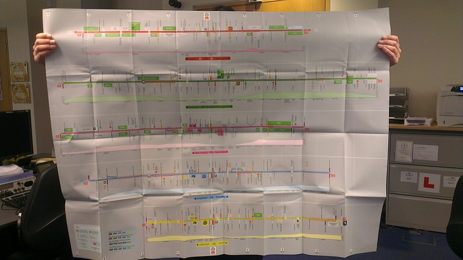
This map is identical to the official network map [pdf], except that the signed (primary) routes are coded in red, and the recommended (secondary) routes are in blue.
What can we say about it? Well, the primary routes are arranged a little bit in the form of a wagon wheel, which seems sensible. However, whilst I was copying out these routes, my constant thought was that their course was informed by the same principles which guided the architects of, say, the Darlington Cycling Network.
In other words, the quietest routes were chosen in preference to the most direct routes, in order to "ensure they appealed to less experienced cyclists, who might be less likely to cycle if it meant cycling on road" (Cycling England). In the case of Darlington, this meant that they embarked on a strategy which focused on the reason people do not cycle—because it's "dangerous"—without doing very much to build on the reason people do cycle—because it is quicker and more convenient than the alternatives.
To quote LTN 2/08: "The underpinning principle is that measures for [...] cyclists should offer positive provision that reduces delay or diversion and improves safety [my emphasis]."
The dark-green sections indicate that some form of segregation from the traffic is in place (typically this means a shared-use path, though not exclusively). The light-green sections indicate a cycle lane. The light-blue sections indicate a cycle lane, but which is not shown on the official network map (for some reason). The orange sections indicate a route which has been signed (sometimes with stickers). The red sections we're going to look at now, beginning in the centre of the map.
Heigham Street (A1024), Norwich
As I was thinking about what to write for the section of route shown in the two photos above, I was minded to look at the relevant guidance in the Mayor of London's Vision for Cycling:
Where directness demands the Quietway briefly join a main road, full segregation and direct crossing points will be provided, wherever possible, on that stretch.The Mayor has a thousand million pounds to spend on cycling over the next ten years, and with that sort of money available, clearly he is going to be able to afford to do things like this. However, for those authorities in the rest of the country which are keen to develop an amenable cycling environment, but which do not have access to such abundant resources, what are the options? Bearing in mind that a solution which cannot be paid for is not a solution, is it in fact the case that less sophisticated, more immediate solutions would be appropriate, for the time being at least?
Heigham Street (A1024), Norwich
The photo above left is looking back towards the southbound continuation of this route. It's difficult to see, but there is actually a sticker on the back of that post in the bottom left of the picture (the one supporting the traffic warning sign). Assuming the pavement on the left isn't a shared-use path—there is nothing to indicate that it is—this is the full extent of the "infrastructure" on this section of route—which means to say, that not even a dropped kerb has been installed.
To quote LTN 2/08 again: "Dropped kerbs are particularly beneficial to [cyclists ... because] even a very small step can be uncomfortable and irritating for users."
Regular readers of this blog will know that I often write about the "prudence" of "introducing" the cycling network by doing as much as possible at least bureaucracy first; but putting up stickers on posts is not really what I had in mind. Something like the picture on the right is more like it, but even having said this, I have to make clear—because some people bend over backwards to misunderstand me—that there are certain aspects of this layout which I don't much care for; and in any case, I am talking here about where to start, and not where to end up.
Sprowston Road (A1151), Norwich
Here is another section which features a standard road layout. In the photo above left, you can just about make out a direction sign (in between the parked cars). In the photo above right, there are no signs around the junction that I could see.
Thorpe Road (A1242), Norwich
Before we consider the "infrastructure" shown in the photos above, I would like for us to be reminded of the procedures "that allow rational decisions to be made with the minimum of bureaucracy", to wit:
• set clear and concise scheme objectives;Firstly, to set clear and concise scheme objectives. Very briefly, it's a top-down (holistic or global) approach that I am advocating, so network first and then a separation of functions.
• work up the design against these objectives; and
• review the design against these objectives through a quality audit.
Secondly, to work up the design against these objectives. There is more to it than simply laying down repeat markers on the road surface, but the purpose of doing so is threefold:
1. They enable the network to be "introduced", relatively quickly and relatively cheaply. Thereby, this serves to establish the network, ensuring that more highly-engineered solutions can be developed within the framework provided by a functioning cycle network.
2. They help to reduce potential conflict by raising the awareness of drivers. As Sam Saunders explains: "The development of a settled culture of city transport will depend on consistency, predictability and regular physical cues. Consciously wondering what rules or possibilities are likely in a given situation, while trying to find a route or deal with an immediate problem overloads the attention span, increases anxiety and increases errors—for all."
3. Adapted, they can also function as route confirmation markers. As the Mayor of London's Vision for Cycling remarks in connection with the Quietways: "They will be clearly signed, mostly on the road itself, making it impossible to lose your way."
 |
| BBC Radio Norfolk finds out how easy it is to cycle in Norwich |
Lastly, to review the design against these objectives. This means (to quote LTN 2/08 again): "The assessor should determine if the proposal improves upon the existing situation and whether any risk is justified when compared with alternative solutions."
| The feeder lane on Thorpe Road (at the junction with Harvey Lane) |
In the Summer 2012 newsletter from the Norwich Cycling Campaign, the following comment appeared "from the Chair's office":
Thorpe Road – we had been asked to comment on the cycle symbols and other changes. The general feeling of the meeting was that the symbols were not helpful, and that the feeder lane at Harvey Road (i.e. running between two motor traffic lanes) is not safe. This response was fed back to the City Council’s cycling officer.In the Spring 2012 newsletter, the following comment appeared "from the Chair's office":
Norwich Cycling Campaign members have expressed concern about the cycle waiting area that has been installed at Dereham Road inbound at the bottom of Grapes Hill. While the creation of the advanced stop line (ASL) for cyclists is welcome, the lack of any sort of feeder lane to reach it (preferably between the second and third parallel lane of queuing traffic) creates difficulties and potentially intimidating cycling conditions for people on bikes heading for St Benedict’s Street. Apparently another cop-out by the design engineers in the quest for ever more road space for motor vehicles.
Dereham Road near the junction with Grapes Hill
Thus, when the council install a feeder lane running between two lanes of motor traffic on Thorpe Road, this is deemed "not safe". But when the council fail to install a feeder lane between two lanes of motor traffic on Dereham Road, this "creates difficulties and potentially intimidating cycling conditions."
 |
| Photo credit: Bicycle Dutch |
I wouldn't mind so much, but when I suggested to the Cycling Officer in Norwich that laying down repeat markers on the road surface would be an effective way forward—zero to one being the hardest step to take, with zero being where we are now, and one being a functioning, comprehensive, city-wide cycle network—he replied that they had tried these repeat markers once before, but given the strength of feeling from the local Cycling Campaign group, he said that they wouldn't be making that mistake again.
Because the fact of the matter is, as Mark Ames recently reminded us, campaigning works. The authorities listen to campaigners. They listened to those campaigners who advocated the Hierarchy of Provision, for example.
It is written in the Mayor of London's Vision for Cycling: "Timid, half-hearted improvements are out—we will do things at least adequately, or not at all." All I would say about this is that campaigners need to be very careful indeed about what they wish for.
No comments:
Post a Comment