I have never worn lycra. I'm not really a "cyclist" at all. But I did use to cycle to school, mostly along main roads.
I got myself a little moped when I was 16, and didn't cycle much thereafter. Then, in the summer of 1999, when I was 33, I got a job hiring bicycles in Richmond Park. The weather was good that year, and the hire bikes were very popular. What I particularly remember is the big smiles on the customers' faces as they returned the bikes.
I thought these hire bikes were a jolly good idea. And so I reckoned I would look at other locations in London, to see whether it would be profitable for me to set up a hire bike facility somewhere else. The first place I looked at was Hyde Park.
At this time I was living in South Wimbledon. One day, having spent the morning looking around Kensington and Westminster, I fancied a change of scene, and armed only with an LCN map and a central London tourist map, I headed across town to Victoria Park.
From Victoria Park I went down alongside the canal to the Isle of Dogs, and thence via the foot tunnel to Greenwich. By this time, however, it was starting to get a bit late, and so, after a quick look around, I headed off towards home. Looking at the LCN map now, I have absolutely no idea which route I was planning to take.
I recall seeing a cycle route direction sign that was pointing my way, and which I decided to follow. The route was signed for about a mile or so, and then, all of a sudden, when I got to the end of some residential street, at a junction with a main road, the signs just stopped.
Why? Cars and lorries were using this road in both directions, so it wasn't as if the route wasn't
functional, or anything like that.
My idea to code routes according to the direction of travel had its genesis in this moment. I was lost, and I had no idea how best to continue my journey. But it was whilst I was looking at the layout of the road on the Lambeth side of Waterloo Bridge that I had another idea.
By this time, my thoughts regarding hire bikes had blossomed. I envisioned a vast network of hire bike stations, not entirely dissimilar to the current scheme, though the operation would have been somewhat different. However, I was of the view that in order for the scheme to be successful, people would need to be able to navigate their way around safely and conveniently, and with things as they were back then, I didn't think this was possible.
So I was looking at the LCN routes, and thinking, this isn't too bad, and that's not too bad either, and if the authorities just did this here, and that there, then things would start to fall into place. But as I got more and more into it, I began to realise that the list of things the authorities needed to sort out was getting bigger and bigger, to the extent that it was becoming overwhelming.
Therefore, I recognised, something had to give. There was just so much to be done. Some time later I read in
Cycling: the way ahead that introducing the network to a minimum level of functioning was regarded as "a prudent course to follow." I was very excited by this, since I reckoned this would be the key to unlock the potential of my new signing strategy.
The map above shows most of the important 'strategic' and 'local' routes in the West End of London. The next thing to be done, having identified these routes, and planned the network, is to study the feasibility of introducing the whole. Indeed this is regarded as being of "a similar importance" to appointing a Cycling Commissioner.
One-way streets
In this part of London, one of the biggest practical difficulties to be overcome is all of those one-way streets.
For the most part, I agree with
Rachel Aldred when she says:
"Always, always, two-way cycling should be permitted, to maximise the potential cycling network [...]
"Contraflow cycling has been implemented safely in the City of London, even on very narrow streets. Further afield, in higher-cycling countries, it’s assumed that you provide two-way cycling throughout the road network. Contraflow cycling should be a no-brainer. [...]
"[...] There should be an authority-wide programme to legalise contraflow cycling more broadly. [Moreover,] a scheme should never be proposed that retains one-way cycling restrictions, unless accompanied by some excellent and evidenced reasons."
The first of Rachel's four key points is as follows: "Like two-way pedestrian flows, two-way cycle flows should be the default, whatever the restrictions on motor traffic."
I agree very strongly with this. Of course, given the current state of the cycling environment—the sheer number of one-way streets in this part of London, coupled with some very hostile conditions for utility cycling on most of the main roads—I imagine it would take quite some time for all of the one-way streets to be converted. For this reason, therefore, it would make for a very good start—it seems to me—if the various
routes could be made to function in both directions.
Royal Parks
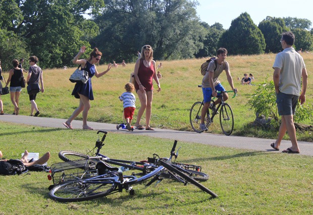
We have seen recently that research from TfL shows how highly people regard the opportunity to incorporate a bit of greenery into their journey. On the other hand, these spaces need to be shared with other people, some of whom are seeking a refuge from the hustle and bustle of city life. (That is a story in and of itself, of course.)
 |
| Photo credit: London Cyclist |
There is no suggestion that cyclists should be above the law; but this said, these things have to be able to work in balance. Alas! the scales seem to be weighed so heavily against cycling—even considerate cycling—that it becomes difficult to imagine what sort of things would need to be done just in order to get everything back onto an even keel.
Consider what happened recently to
Lucie:
"I just got fined £50 for cycling in Regent's Park [...] I have only just started to earn money, and I cycle partly because public transport is so expensive! It seems ridiculous that I now have to pay for cycling slowly through a park which is the highlight of my day!"
Does that seem ridiculous to you, too? Not so long back, a Radio 4 audience voted the bicycle
the greatest invention of all time (by a
massive margin, incidentally). And yet,
Cycling: the way ahead suggests that "
the worst enemies of cycling" in the built-up area are not motor vehicles, but "
longheld prejudices". How is such astonishing inconsistency to be explained?
 |
| Hyde Park (see route below) |
I understand that the police receive relatively a lot of complaints about cyclists, but how much of this, I wonder, is a consequence of the environment? For example, if the 'No Cycling' restrictions were removed from certain paths in certain parks, would the people who don't ride bicycles genuinely still have reason to complain about the people who do?
'Functionality' maps
I still haven't actually finalised a proposed design for the central London area. But it is easier to look at the functionality of individual routes, rather than of the network as a whole. So here goes ...
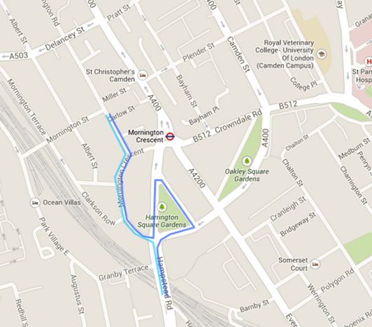
Dark Blue-coloured routes
There is a potential cycle route from Hyde Park Corner up to Regent's Park. For a long time, I had thought that the best course for this route to follow would be via Hamilton Place and Derby Street (as shown in lilac in the map below). However, in recent years, I have identified an alternative way to go.
Upon leaving the Park—the gate is somewhat diminutive at the moment, and is just next to a black-backed noticeboard in the first one of the pictures below—you are immediately confronted with the generously-proportioned A4202.
The Mayor said on LBC that he understood what cycling campaigners are saying. They are saying, 'Give us cyclists that space on the road for us to use exclusively.' The Mayor says that he would love to be able to do that, but the difficulty is, there are lots of other people who are contesting that space. "This is a shared space we live in," he reminded us, "and these other people need to use that space as well."
In the middle photo above, we can get a better sense of just how much space these other people actually need. No, it's too much. A double-width filter lane, three lanes of northbound traffic, plus about 10-12 feet of hatched lines? Cripes! This is
excessive.
Assuming there are no real difficulties converting the path in Hyde Park to accommodate cycle traffic, it should be possible to get to the junction above without too much difficulty. But here's where the fun starts.
However this crossing is organised, I do believe there is a very clear need to provide for some link between Mayfair and Hyde Park.
 |
Cycling is not allowed in the pedestrian underpass, so how else are the ladies
and gentlemen who ride bicycles to get from Hyde Park Corner to Mayfair? |
Once you are in Mayfair, things are relatively plain sailing on South Audley Street, as far as the junction with Grosvenor Square.
I am not sure whether cycling is now officially permissible in front of the American Embassy. When the road was closed to vehicular traffic a few years back, there was a suggestion that allowing cycle traffic to use this route would be "a threat to security".
Lastly on this route, there is a one-way section of road on Brook Street (about 70 metres in length) which ideally would be two-way for cycle traffic. Interestingly, that road which the man in the red top is crossing in the right-hand photo is almost totally superfluent (except for car-parking) (Street View
here).
With regard to Tottenham Court Road, there are some excellent reasons why it should be enabled to accommodate two-way cycling. However, as I have read, this has not happened yet because of concerns about motor traffic capacity.
I am a bit reluctant to stray too far into areas I don't know much about, but if Gower Street was converted to allow two-way motor traffic, then the number of different things that could be done with Tottenham Court Road would surely be extended. In this event, the buses and black cabs and bicycles could use Tottenham Court Road, say, and the cars and vans and lorries could use Gower Street.
(Key to map: northbound motor traffic in dark-blue, southbound traffic in light-blue.)
It is a feature of the roads in this part of London that most of the north-south routes are aligned at about twenty-five past eleven. In the City, by contrast, most of the north-south roads are aligned at about twenty-five to one.
Anyway, I am going to take a close look at the proposed section of route which connects Hyde Park with Great Cumberland Place. Let's begin by seeing how cyclists currently make this journey.
It's a two-stage crossing, and at times, it can get quite busy.
On the northern side of Marble Arch, a lot of cyclists have worked out that when the traffic lights on Great Cumberland Place show green (photo on the left), all of the motor traffic is forced left (photo on the right). This makes it possible to transit the junction safely.
However, this still leaves a sub-conflict between pedestrians crossing the northbound carriageway of Great Cumberland Place and cyclists heading north from Marble Arch (photo on the left). With so much space available here, I would be surprised if it was not possible to find a satisfactory solution.
So that's how cyclists do things at the moment. However, rather than going through Hyde Park, there is another way to approach Marble Arch, and that is to go via the central reservation! Let's take a closer look.
The idea is to leave Hyde Park at Brook Gate, pass in front of The Animals in War Memorial, and then enter the central reservation alongside the southbound carriageway of the A4202. The distance between here and Marble Arch (photos below) is just a little bit over 200 metres.
You can make your own mind up as to whether this is a realistic option. I would just point out, however, that the pedestrian traffic around Speaker's Corner can get very heavy.
At the junction itself, the big problem is finding a way to continue northwards to Great Cumberland Place. It bears repeating that there is a lot of carriageway space around here.
I am finished looking at this route for now. I briefly looked at a crossing of the A501 via Harley Street during
A study of Camden, so I won't spend any time on it here.
For more information on the route Trafalgar Square - Whitcomb Street - Wardour Street, please see Danny Williams' report
here.
Amongst all the other Light Blue-coloured routes, there is a (largely) non-functioning section between Victoria Embankment and High Holborn via Chancery Lane. Who would use such a route? One such person is Clare H, who lives in Fulham and works in Holborn. She points out (
here) that when she first moved to London, she lived on Oxford Street in student halls. Her university was in Bloomsbury—an easily cycle-able distance—but there was no way she was going to cycle down Oxford Street.
"Then I moved to Fulham and got a job in Hammersmith," she said, "and cycling felt more achievable and desirable—especially after one journey too many stuck on the bus in a traffic jam. My boyfriend has always cycled and helped me find a safe route through a park and down quiet roads. And I discovered the freedom of cycling.
"But when I got a job in Holborn cycling felt unachievable again—the roads in central London looked too dangerous. But after too many depressing and expensive tube and bus journeys, and missing the freedom cycling gave me, I nervously took to the roads again and now cycle to work every day.
"Now I am more confident cycling in central London, but there are places I get off and walk (Parliament Square, Aldwych), and I still feel nervous going off my known route. I’d like to be able to encourage my friends to choose to cycle too, but they look at the roads and decide it’s too scary. I know they would take it up if there were safe traffic-free routes. And I know my commute would be safer and more pleasant that way too. But too often the lack of decent infrastructure makes what could be a safe and pleasant route more dangerous than it needs to be."
Clare later explained that, to get to work, she goes “along Chelsea Embankment (on the shared-use pavement), then on CS8 to Parliament Square (get off and walk), then along Victoria Embankment (hoping for the best along there), turning left before Temple, up Arundel St (then get off and walk), then up Chancery Lane, winding around High Holborn and ending up at Red Lion St. Phew!”
It was a different way home, of course.
Parliament Square and Victoria Embankment are to be treated as part of the Mayor's flagship route, but as far as I know, this scheme would do nothing to address other difficult bits of Clare's journey.
The first problem is to get from Victoria Embankment to the eastbound carriageway of The Strand.
The second problem is Chancery Lane, which is one-way for its entire length.
Green-coloured routes
There are some horrible junctions which are marked as 'functional' in the map above. I hope nobody is fooled into thinking I am suggesting something which I am not. I am not looking to fool anybody—least of all myself.
I looked at Grafton Way - Gower Street - Gower Place during
A study of Camden.
Further along this route is a path in Hyde Park. Now, it is perfectly true that cyclists could go the long way around, but what a shame it is that for most of the time these paths are largely empty.
There is a route between Knightsbridge and King's Cross which is marked as having some non-functioning sections. I have already looked at the crossing of Park Lane from Hyde Park into Mayfair.
The photos above are both of Noel Street, the first one looking east, the second one looking west.
The photo on the left shows the approach to the one-way section of Goodge Street, and on the right the entrance to Chenies Street.
Below, various views of Carburton Street
Below left, Great Portland Street at the junction with Carburton Street, looking north towards Devonshire Street. Below right, Great Portland Street near the junction with Devonshire Street, looking south towards Carburton Street.
Below left, a view of the junction at Devonshire Street and Great Portland Street (looking west). Below right, a view of the one-way section on Devonshire Street (looking east).
Another non-functioning section which is marked on the map above is in Hyde Park.
The route is functional from West Carriage Drive as far as The Old Police House, but thereafter the route heads south towards The Serpentine. In fact, the desire line is straight on (in the photo on the left).
Above, a couple of pictures of the proposed route across the park.
It's the one in the middle.
Orange-coloured routes
Below are two different views of Vigo Street, the first one looking east, and the second one looking west.
Vigo Street starts at the junction of Savile Row and Burlington Gardens. The map below shows the current layout of the one-way roads in this part of Mayfair.
Ideally the route Vigo Street - Glasshouse Street - Brewer Street would work in both directions for cyclists.
Question: Could the section of Vigo Street between Regent Street and Sackville Street be reconfigured in some way? Perhaps the one-way could be made to work in the opposite direction?
Above, two views of the junction across Regent Street, the first from Vigo Street, the second from Glasshouse Street.
Above, two views of Brewer Street.
Above, a view of the route between West Street and Moor Street.
Above, three views of some of the one-way streets in Covent Garden.
Circular route
The Way Ahead
Cycling: the way ahead points out: "All of the installation measures which call for little planning may be applied without major risk of error or loss [...] Given their low cost, the small amount of extra work which they entail and the possibilities of corrections in the case of error, such measures may be adopted automatically."
Only by studying a cycle route network is it possible to "truly grasp the
situation" and to "act in a targeted and highly efficient fashion."
The sections marked in blue are to be the subject of another blog. The other coloured sections are not yet 'functional'.
The changes indicated in the map above go a little beyond a network
"introduced" to a minimum level of functioning, and should be completed
by the medium-term.
"If it is not possible to systematically remodel the entire network to better meet the needs of cyclists [all in go], specific action can be taken on each occasion that works need to be done. Most of the time, the additional expenditure needed to meet the requirements of cyclists is comparatively minimal."


.gif)