"What is needed," the LCC's Go Dutch
advocate explained in a video that was presented to the membership, "is a
strategic network of routes that look really attractive to cycle on." This
is true not just in London, but in every town and city in the UK. The question
is, firstly, Do you accept this? and secondly, How would you set about
developing such a network?
I explained in some considerable detail how best
to set about this task in an article that was published on the Movement for Liveable London website. The
long and short of it, however, is thus:
1. Think in
terms of a network.
Only by studying a cycle route network will it be possible to truly grasp the situation. (p.40, Cycling: the way ahead)
2. Plan the network.
Analyse journeys — origin/destination (headcounts, statistics, interviews). (p.56, Cycling: the way ahead)
Design from patterns to details.
3. Study the feasibility of the network.
Studying the feasibility of a network is of a similar importance to setting up a cycling unit or appointing a cycling coordinator. (p.57, Cycling: the way ahead)
4. Introduce the network.
The level of minimum functioning is a prudent course to follow. (p.56, Cycling: the way ahead)
5. Develop the network.
Strengthen the network further on the basis of priority interventions and a timetable. (p.56, Cycling: the way ahead)
The key here is sustained investment, progressively reprioritising the urban environment in favour of more sustainable forms of transport.
* * *
Who is the
investment in cycling infrastructure for, and why do we make that investment?
Is it for those who are already cycling, or is it for those who are not?
Those of you that keep a close eye on the cycling blogs will recognise that these questions were posed recently by Freewheeler, who himself was quoting the Cambridge Cyclist. For myself, I am of the view that the introduction of a functioning cycling network should be undertaken with existing cyclists in mind first and foremost. Let me explain why.
The important thing is to get the network up and running, not least because a network is more than the sum of its parts. (For an alternative view on the power of networks, you might like to watch this video.) Making it safe enough such that unaccompanied children can use it, say, would come afterwards. Indeed, there is absolutely no reason why this work couldn't be started immediately afterwards (Step 5 demands that there is a timetable in place). But first things first.
The minimum requirements for a functioning cycle network are that the routes should be:
(i) meaningful (i.e., they go to the places that people want to get to);
(ii) direct;
(iii) pleasant (wherever possible, but never to the detriment of the first two-listed factors);
(iv) joined up (a network, by its very definition, is inter-connected);
(v) functional in both directions; and,
(vi) effectively waymarked.
I am not aware of any town or city in the UK
that can meet these minimum requirements. I am currently staying in Reigate,
and I have just cycled to the shops. No problem for me. I am much more of a
fair-weather cyclist than the Cambridge Cyclist, but even so, I am not put off
by a bit of vehicular cycling. However, coming back from the shops, I found
that I couldn't reasonably make this journey without breaking the law! How
absurd is that? According to a Radio 4 audience, the bicycle is the
greatest invention of all time. In which other countries in the world, and
in what circumstances, could riding one of these beautifully simple machines
ever be regarded as a criminal offence?
One commentator has recently said that
"the screaming-out need [...] is to have the majority of the population
onto bikes for everyday trips." No. That's our destination: in the
short-term, there are more pressing demands.
Mikael Colville-Andersen of Copenhagenize has
said, "'Badly-behaved' cyclists are usually just cyclists with inadequate
infrastructure" (quoted not so long back by AsEasyAsRiding). Providing 'adequate'
infrastructure for existing cyclists is, I would argue, "the screaming-out
need".
Who is the
investment in cycling infrastructure for, and why do we make that investment?
Is it for those who are already cycling? Yes, to begin with, why not? They're the ones who are being
killed and seriously injured! They're the ones who break the law just to get
back from the shops!
* * *
Cambridge is the cycling
capital of the UK, but even so, it does not have a functioning cycle
network. Indeed, the cycle map [pdf] produced by the local authority
shows only the routes in that city.
If the City of Cambridge is minded to develop a
network, I would recommend that they follow the five-step plan indicated at the
top. Step 2 requires that the network is planned, designing from patterns to
details. Since a significant number of routes have already been identified
in Cambridge, I thought I would see for myself if it were possible to join
these routes up to form a network.
* * *
Compass colours code routes according to a direction
of travel, as can be seen here. (This map, and all the ones that follow,
are best viewed with the terrain box (top right) ticked.)
As you can see, all I have done so far is to lay
down one route in each of the five compass colours (plus the circular route,
which is coded in yellow), but still, you can easily see how this would give
the network its identity.
Next I coded the other primary routes on this
network, as can be seen here (don't forget to tick the terrain box).
Actually, there are a few new sections of cycle route which appear on this map
but which do not appear on the Cambridge cycle route map as produced by the
local authority. These are:
(i) The top half of Elizabeth Way (A1134) (coded
in cyan);
(ii) Northampton Street (A1303) (coded in
orange);
(iii) Mill Road / Parkside / the bottom half of
Parker Street (coded in orange);
(iv) A farmer's track between Long Road (A1134)
and Grantchester (coded in red).
In each case, I can see that there are
alternatives to the new bits, but just to say, I haven't incorporated them into
the proposed network for my benefit. The fact is, the new
sections provide for more meaningful and more direct journeys, and if the
authorities in Cambridge are serious about cycling, this is the sort of thing
that they would need to pay attention to.
After this, I coded what I call the secondary
routes, as can be seen here. My proposed design for a strategic cycle
network in Cambridge is now complete.
As before, I have added a couple more new
sections:
(i) Chesterton Lane / Chesterton Road (A1303)
(coded in red);
(ii) an alternative course for NCN Route 11
south of the Botanic Gardens (coded in cyan).
There are some 'blue' routes on the City of
Cambridge map which I haven't been able to code. See here.
This proposed design comprises 16 routes. With
relatively so few routes (my proposed design for London is made up of about 70
routes), there are other coding options available, the most obvious being one
colour per route. But we are not very far from the absolute limit of this
strategy, in the sense that once you get to about two dozen routes, you start
to run out of colours.
* * *
I would say, get the network up and running,
and do that as quickly as you can. Or else, why would you not?
Churchill has said: "The maxim, 'Nothing
but perfection' may be spelled 'paralysis.'" Dom Nozzi expressed this idea
more forthrightly: "If you are
an elected official lacking in courage and leadership, and you face even a peep
of opposition to a project, fall back on perfectionism to find the flaws so
that you can shoot down the project. Perfectionism leads to paralysis."
Once the network has been introduced, it would be further strengthened on the
basis of priority interventions and a timetable. I imagine that some local
authorities might want to sort out one or two junctions first, even if the works done
serve only as an interim measure, before introducing the network in its
entirety. That would be quite understandable. But the essential thing is to
make that commitment.
* * *
There are two big advantages with using compass
colours. Firstly, as the city expands -- as it inevitably will -- you can add
further routes without compromising the simplicity and elegance of the design.
Secondly, it is useful even without a map. One comment on the Cycle Lifestyle
website reads: "I occasionally park in Hyde Park and cycle to Holborn
[...] just know the general direction and take off."
Thus, a network coded using compass colours
gives cyclists the opportunity for spontaneity. The big disadvantage is that it
is not always possible to code little bits of route. Still, if we're wanting to
create a strategic cycle network, then we can't always be too
concerned to code every single bit of cycle route, particularly if they have
limited strategic value.
The cycle route map produced by the City of
Cambridge also shows what they call local links. These can be seen here.
* * *
I was prompted to start work on a design for a
Cambridge Cycling Network primarily in response to the Cambridge Cyclist's
questions about who for? I do take his point about Gilbert Road. It seems to me
that the hardest decision has already been taken, to wit, to remove the
on-street parking.
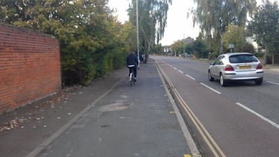 |
| Gilbert Road (Photo by Richard Taylor) |
A reallocation of carriageway space is self-evidently not going to be enough for some of the people who ride bicycles; they are going to need more than that, and if the local authority is really serious about the bicycle as a mode of transport in its own right, they need to recognise this.
But I would also urge all towns and cities in the UK to have an eye on the bigger picture as well. And that means thinking in terms of a network.
Once you have a functioning cycle network, then you have a solid base, and as anyone who has ever tried to build on sand would tell you, that makes all the difference in the world.